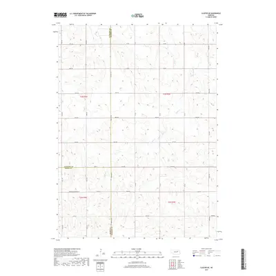
2017 Map of Closter NE
USGS Topo · Published 2017About this map
The agricultural divide of the Nebraska plains is clearly defined here at the convergence of Madison, Antelope, and Boone counties. This section of the Great Plains is dominated by the sprawling drainage basins of Buffalo Cr and Giles Cr, which carve subtle topography through the strictly partitioned landscape. The map illustrates the precision of the Public Land Survey System, where a rigid grid of section lines—marked by routes like 835th Rd and 535th Ave—imposes order over the natural meandering of waterways. State Hwy 45 serves as a primary north-south artery, tracking along the Madison County line. Local transit history is visible in the network of unpaved paths, including a designated Minimum Maintenance Rd, highlighting the functional nature of rural infrastructure in this central Nebraska farming region during the early twenty-first century.
Find a feature on this map
32 named features on this map. Tap any name to fly to it.
Don’t see what you’re looking for? This feature index may not catch every label — zoom into the map to look around manually.
Map Details
Editions of this 2017 Closter NE Map
This is the sole edition of this map. No revisions or reprints were ever made.
Other maps of this area

1955 · Sioux City
USGS Topo · 1:250,000

1955 · Fremont
USGS Topo · 1:250,000

1957 · Fremont
USGS Topo · 1:250,000

1958 · Sioux City
USGS Topo · 1:250,000

1958 · Fremont
USGS Topo · 1:250,000

1959 · Sioux City
USGS Topo · 1:250,000

1963 · Closter SW
USGS Topo · 1:24,000
1963 · Oakdale
USGS Topo · 1:24,000

1963 · Emerick
USGS Topo · 1:24,000

1963 · Meadow Grove
USGS Topo · 1:24,000