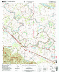
2003 Map of Cloutierville
USGS Topo · Published 2005About this map
The Cane River Lake meanders through the heart of Natchitoches Parish, defining a landscape of alluvial plains and established riverside settlements. Historically significant communities like Melrose and Magnolia sit along the winding banks, where the legacy of early Louisiana plantation culture is still visible in the dense clusters of dwellings and local landmarks. To the south, the terrain shifts abruptly into the Kisatchie Hills Wilderness and the Red Dirt National Wildlife Management Preserve, where high ridges and managed forest replace the river-bottom agriculture. Small rural churches and schools, such as St Augustine Ch and Spring Hill Sch, serve as focal points for the dispersed populations at Derry and Lakeview. The presence of the Red River in the northeastern corner further emphasizes the importance of these waterways to the region’s transport and topographic development.
Find a feature on this map
54 named features on this map. Tap any name to fly to it.
Don’t see what you’re looking for? This feature index may not catch every label — zoom into the map to look around manually.
Map Details
Editions of this 2003 Cloutierville Map
This is the sole edition of this map. No revisions or reprints were ever made.
Other maps of this area

1935 · Verda
USGS Topo · 1:31,680

1937 · Chopin NE
USGS Topo · 1:31,680

1937 · Bermuda
USGS Topo · 1:31,680

1937 · Chopin NW
USGS Topo · 1:31,680

1937 · Aloha
USGS Topo · 1:31,680

1937 · Montgomery
USGS Topo · 1:62,500

1937 · Cloutierville
USGS Topo · 1:31,680

1937 · Cypress
USGS Topo · 1:31,680

1942 · Kisatchie
USGS Topo · 1:62,500

1942 · Montgomery
USGS Topo · 1:62,500