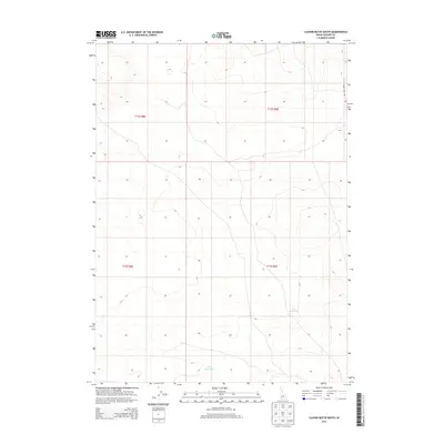
2013 Map of Clover Butte South
USGS Topo · Published 2013About this map
The high plateau of Owyhee County is defined here by wide-ranging topography and isolated water sources used for land management and livestock. Leo Waterhole and Valley Waterhole serve as critical landmarks in this arid environment, where elevation contours reflect the subtle undulations of the high desert landscape. The presence of Three Creek Rd in the northeastern corner of the map indicates the primary transit corridor through this sparsely populated territory. Produced in 2013, the survey provides a clear view of the Public Land Survey System divisions, including Township 12 South and Township 13 South across Ranges 8 East and 9 East. This map is particularly useful for understanding the distribution of water resources and access points in a region where such features were essential for both early ranching operations and modern land use.
Find a feature on this map
7 named features on this map. Tap any name to fly to it.
Don’t see what you’re looking for? This feature index may not catch every label — zoom into the map to look around manually.
Map Details
Editions of this 2013 Clover Butte South Map
This is the sole edition of this map. No revisions or reprints were ever made.
Other maps of this area

1955 · Twin Falls
USGS Topo · 1:250,000

1958 · Twin Falls
USGS Topo · 1:250,000

1978 · The Arch
USGS Topo · 1:24,000

1979 · Stiff Tree Draw
USGS Topo · 1:24,000

1979 · Clover Butte South
USGS Topo · 1:24,000

1979 · Mosquito Lake Butte
USGS Topo · 1:24,000
1979 · Poison Butte
USGS Topo · 1:24,000
1979 · Inside Lakes
USGS Topo · 1:24,000

1980 · Juniper Butte
USGS Topo · 1:24,000

1980 · Clover Butte North
USGS Topo · 1:24,000