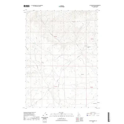
2020 Map of Clover Mountain
USGS Topo · Published 2020About this map
Clover Mtn stands as a central high point in this high-desert portion of Owyhee County, where the drainage patterns of Clover Cr and the S Fork Castle Cr define the landscape. The geography is characterized by broad plateaus and named draws, such as Summit Flat, Grassy Flat, and the distinctively named Bill DeAlder Draw. This 2020 survey illustrates a region where water is the primary driver of names and land use, evidenced by scattered reliable points like Clover Spring, Rat Spring, and the Sheep Cr Pond.
Find a feature on this map
29 named features on this map. Tap any name to fly to it.
Don’t see what you’re looking for? This feature index may not catch every label — zoom into the map to look around manually.
Map Details
Editions of this 2020 Clover Mountain Map
This is the sole edition of this map. No revisions or reprints were ever made.
Other maps of this area

1955 · Jordan Valley
USGS Topo · 1:250,000

1957 · Jordan Valley
USGS Topo · 1:250,000

1958 · Jordan Valley
USGS Topo · 1:250,000

1965 · Triangle
USGS Topo · 1:62,500
1972 · Rough Mountain
USGS Topo · 1:24,000
1972 · Pixley Basin
USGS Topo · 1:24,000
1972 · Big Springs Ranch
USGS Topo · 1:24,000
1972 · Crab Spring Butte
USGS Topo · 1:24,000
1972 · Snow Creek
USGS Topo · 1:24,000
1972 · Clover Mtn
USGS Topo · 1:24,000