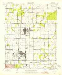
1946 Map of Clovis
USGS Topo · Published 1956About this map
Hammer Field dominates the southern landscape of this mid-century survey, reflecting the era's military footprint on the outskirts of Fresno. The map captures the agricultural and suburban transition of the Central Valley, where a meticulous network of irrigation systems like the Enterprise Canal and Colonial Ditch feeds the surrounding orchards and fields. Smaller rail stops and colonies, such as Tarpey, Glorietta, and Kutner Colony, are connected by the Southern Pacific and Atchison Topeka and Santa Fe railroads.
Find a feature on this map
74 named features on this map. Tap any name to fly to it.
Don’t see what you’re looking for? This feature index may not catch every label — zoom into the map to look around manually.
Map Details
Editions of this 1946 Clovis Map
This is the sole edition of this map. No revisions or reprints were ever made.
Other maps of this area

1921 · Bullard
USGS Topo · 1:31,680

1922 · Round Mountain
USGS Topo · 1:31,680

1922 · Lanes Bridge
USGS Topo · 1:31,680

1922 · Friant
USGS Topo · 1:31,680

1923 · Malaga
USGS Topo · 1:31,680

1923 · Academy
USGS Topo · 1:31,680

1923 · Fresno
USGS Topo · 1:31,680

1923 · Clovis
USGS Topo · 1:31,680

1923 · Sanger
USGS Topo · 1:31,680

1923 · Bullard
USGS Topo · 1:31,680