Loading...
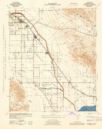
Loading map...1943 Map of Coachella
USGS Topo · Published 1944About this map
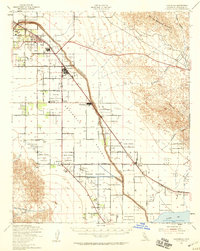
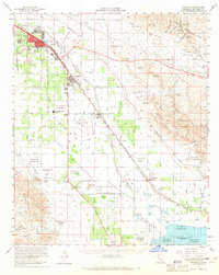
The Coachella Valley unfolds as a complex agricultural and tribal landscape during the early 1940s, anchored by the growing hubs of Indio and Coachella. This wartime survey reveals an area defined by the Southern Pacific railroad corridor and the vital hydrology of the Whitewater River and the Storm Channel. To the south, the shoreline of the Salton Sea is visible at an elevation of 241 feet below sea level, adjacent to a local Salt Works.
Find a feature on this map
34 named features on this map. Tap any name to fly to it.
Don’t see what you’re looking for? This feature index may not catch every label — zoom into the map to look around manually.
Map Details
Date Portrayed1943
Date Published1944
PublisherU.S. Geological Survey
Map TypeTopographic
Scale1:62,500
Physical Dimensions17.3 x 21.8 inches
Editions of this 1943 Coachella Map
This is the sole edition of this map. No revisions or reprints were ever made.
Historical Maps of Indio Through Time
3 maps found
Featured Locations
Source Details
SourceU.S. Geological Survey
CopyrightPublic Domain