1941 Map of Coachella
USGS Topo · Published 1959About this map
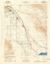
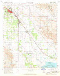
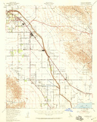
The Coachella Valley unfolds as a meticulously gridded agricultural and desert landscape in this mid-century survey, defined by the vital passage of the Whitewater River and the Storm Channel. The irrigation and transport network is anchored by the Southern Pacific railroad, which links the growing hubs of Indio, Coachella, Thermal, and Mecca. This era shows the region's complex land management, where extensive tribal lands like the Torres Martinez Indian Reservation and Augustine Indian Reservation interface with the expanding geometric township and range road system. Near the southern edge, the Salton Sea shoreline is visible near a Salt Works, marking the lowest point of this arid basin. Local education and community life are represented by landmarks such as the Coachella Valley High Sch and the Ensign Sch, situated among the desert canyons and the rising Little San Bernardino Mountains.
Find a feature on this map
57 named features on this map. Tap any name to fly to it.
Don’t see what you’re looking for? This feature index may not catch every label — zoom into the map to look around manually.
Map Details
Editions of this 1941 Coachella Map
2 editions found

Historical Maps of Indio Through Time
3 maps found