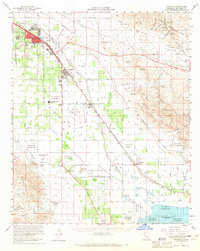
1956 Map of Coachella
USGS Topo · Published 1965About this map
The Coachella Canal and the Coachella Stormwater Channel define this mid-century landscape, illustrating the massive irrigation efforts that transformed the desert floor into a productive agricultural hub. This survey captures a specific era of development between the rising Indio Hills and the northern tip of the Salton Sea. The settlement pattern follows the Southern Pacific railroad, connecting the growing hubs of Indio, Coachella, and Thermal. Extensive tribal lands are documented here, including the Augustine Indian Reservation, Cabezon Indian Reservation, and the broad reaches of the Torres Martinez Indian Reservation. Beyond the irrigated grids, the topography rises sharply into the Mecca Hills and the Little San Bernardino Mts, where labels like Painted Canyon and Skeleton Canyon hint at the arid and demanding nature of the surrounding terrain.
Find a feature on this map
42 named features on this map. Tap any name to fly to it.
Don’t see what you’re looking for? This feature index may not catch every label — zoom into the map to look around manually.
Map Details
Editions of this 1956 Coachella Map
2 editions found
Other maps of this area

1904 · Indio
USGS Topo · 1:125,000

1931 · Vallecito
USGS Topo · 1:125,000

1940 · Cottonwood Spring
USGS Topo · 1:62,500

1940 · Durmid
USGS Topo · 1:62,500

1941 · Toro Peak
USGS Topo · 1:62,500

1941 · Clark Lake
USGS Topo · 1:62,500

1941 · Coachella
USGS Topo · 1:62,500

1941 · Edom
USGS Topo · 1:62,500

1942 · Agua Dulce
USGS Topo · 1:62,500

1942 · Clark Lake
USGS Topo · 1:62,500