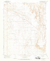
1967 Map of Coal Mine Mesa
USGS Topo · Published 1969About this map
Coal Mine Mesa dominates the high desert landscape of Coconino County, characterized by the intricate drainage systems and steep escarpments typical of the Navajo Hopi Joint Use Area. This 1960s-era survey reveals a sparsely populated terrain where water sources are vital landmarks, evidenced by the First Day of Summer Wells and Beetso Well. The presence of the Coal Mine Mesa Trading Post suggests a local center for commerce and community interaction during this period. To the east, the dramatic erosion of Ha Ho No Geh Canyon and the elevation of Howell Mesa define the local topography. This map documents a specific moment in the administrative history of the region, clearly delineating the Navajo Indian Res Bdy Joint Use Area Bdy and providing a detailed record of the unimproved dirt roads and isolated landmarks like the Radio Tower and a Borrow Pit used for local infrastructure.
Find a feature on this map
14 named features on this map. Tap any name to fly to it.
Don’t see what you’re looking for? This feature index may not catch every label — zoom into the map to look around manually.
Map Details
Editions of this 1967 Coal Mine Mesa Map
This is the sole edition of this map. No revisions or reprints were ever made.
Other maps of this area

1883 · Marsh Pass
USGS Topo · 1:250,000

1883 · Tusayan
USGS Topo · 1:250,000

1886 · Tusayan
USGS Topo · 1:250,000

1886 · San Francisco Mtns
USGS Topo · 1:250,000

1886 · Echo Cliffs
USGS Topo · 1:250,000

1891 · San Francisco Mtns
USGS Topo · 1:250,000

1891 · Echo Cliffs
USGS Topo · 1:250,000

1892 · Marsh Pass
USGS Topo · 1:250,000

1894 · San Francisco Mtns
USGS Topo · 1:250,000

1899 · San Francisco Mtns
USGS Topo · 1:250,000