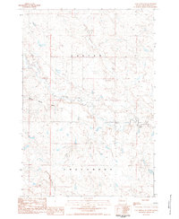
1983 Map of Coal Springs SE
USGS Topo · Published 1984About this map
Thunder Butte rises as the primary landmark in this rural expanse of Perkins County, anchoring a landscape defined by an intricate network of waterways. In the early 1980s, the area remained largely undeveloped, with cattle grazing and land management occurring within the townships of Foster and Englewood. The drainage patterns are clearly mapped, showing how Thunder Butte Creek and Surveyor Creek carve through the prairie terrain. Human activity is sparse but visible through a lone Gravel Pit and the established boundaries of township lines. Small tributaries like Section Draw, Cow Creek, and Spring Creek highlight the natural hydrology of this high plains region, providing a detailed look at the land before modern agricultural shifts or infrastructure expansion altered these drainages.
Find a feature on this map
12 named features on this map. Tap any name to fly to it.
Don’t see what you’re looking for? This feature index may not catch every label — zoom into the map to look around manually.
Map Details
Editions of this 1983 Coal Springs SE Map
This is the sole edition of this map. No revisions or reprints were ever made.
Other maps of this area

1951 · Redelm NW
USGS Topo · 1:24,000

1951 · Faith NE
USGS Topo · 1:24,000

1952 · Faith NW
USGS Topo · 1:24,000

1953 · McIntosh
USGS Topo · 1:250,000

1954 · Lemmon
USGS Topo · 1:250,000

1957 · Lemmon
USGS Topo · 1:250,000

1958 · McIntosh
USGS Topo · 1:250,000

1982 · Glad Valley SW
USGS Topo · 1:24,000

1982 · Glad Valley NW
USGS Topo · 1:24,000

1983 · Coal Springs
USGS Topo · 1:24,000