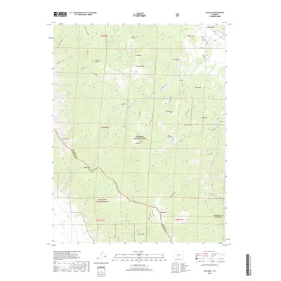
2019 Map of Coaldale
USGS Topo · Published 2019About this map
Coaldale and Pleasanton serve as the primary human settlements in this high-altitude landscape where the Sangre de Cristo Mountains meet the Arkansas River valley. The terrain is dominated by the shared boundary of the San Isabel National Forest and Rio Grande National Forest, split by the sharp ridgelines of the Sangre de Cristo Range. High-country landmarks such as Hamilton Baldy, Hayden Baldy, and Nipple Mtn define the horizon, while drainage systems like Hayden Cr and Black Canyon carve deep paths through the rock. The historic crossing at Hayden Pass provides a vital link across the range, connecting the Fremont and Saguache county lines. Numerous alpine water bodies, including Bushnell Lakes and Stout Creek Lakes, are positioned in the higher glacial cirques, illustrating the complex hydrology that feeds the valley floor via smaller tributaries like Short Cr and Stout Cr.
Find a feature on this map
59 named features on this map. Tap any name to fly to it.
Don’t see what you’re looking for? This feature index may not catch every label — zoom into the map to look around manually.
Map Details
Editions of this 2019 Coaldale Map
This is the sole edition of this map. No revisions or reprints were ever made.
Other maps of this area

1950 · Valley View Hot Springs
USGS Topo · 1:24,000

1954 · Pueblo
USGS Topo · 1:250,000

1957 · Pueblo
USGS Topo · 1:250,000

1958 · Pueblo
USGS Topo · 1:250,000

1959 · Electric Peak
USGS Topo · 1:62,500

1959 · Howard
USGS Topo · 1:62,500

1959 · Cotopaxi
USGS Topo · 1:62,500

1962 · Pueblo
USGS Topo · 1:250,000

1966 · Pueblo
USGS Topo · 1:250,000
1967 · Valley View Hot Springs
USGS Topo · 1:24,000