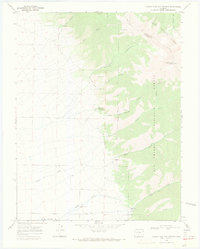
1967 Map of Valley View Hot Springs
USGS Topo · Published 1971About this map
Valley View Hot Springs sits at the base of the Sangre de Cristo Mountains on this 1960s survey, where the complex terrain of San Isabel National Forest and Rio Grande National Forest meets the valley floor. The map highlights a legacy of industrial extraction along the mountain front, specifically the Orient Mine and several other unnamed Mines tucked into Black Canyon and Orient Canyon. An Old Railroad Grade traces the base of the foothills, indicating the former transport corridor that once served these remote workings.
Find a feature on this map
30 named features on this map. Tap any name to fly to it.
Don’t see what you’re looking for? This feature index may not catch every label — zoom into the map to look around manually.
Map Details
Editions of this 1967 Valley View Hot Springs Map
2 editions found
Other maps of this area

1950 · Valley View Hot Springs
USGS Topo · 1:24,000

1954 · Pueblo
USGS Topo · 1:250,000

1957 · Pueblo
USGS Topo · 1:250,000

1958 · Pueblo
USGS Topo · 1:250,000

1959 · Electric Peak
USGS Topo · 1:62,500

1959 · Howard
USGS Topo · 1:62,500

1959 · Cotopaxi
USGS Topo · 1:62,500

1962 · Pueblo
USGS Topo · 1:250,000

1966 · Pueblo
USGS Topo · 1:250,000
1967 · Villa Grove
USGS Topo · 1:24,000