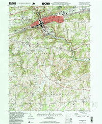
1997 Map of Coatesville
USGS Topo · Published 1999About this map
Coatesville serves as the industrial and social heart of this Chester County landscape, where the Pennsylvania Railroad and the Reading Branch intersect near the Brandywine Creek. The city is flanked by the Valley Hills to the north and the South Valley Hills to the south, creating a corridor of dense development that includes South Coatesville and Westwood. Outside the urban center, the map reveals a rural landscape defined by historic congregation points such as Hephzibah Ch and St Malachi Ch, alongside numerous small cemeteries like St Cecilia Cem and Fairview Cemetery.
Find a feature on this map
65 named features on this map. Tap any name to fly to it.
Don’t see what you’re looking for? This feature index may not catch every label — zoom into the map to look around manually.
Map Details
Editions of this 1997 Coatesville Map
This is the sole edition of this map. No revisions or reprints were ever made.
Other maps of this area

1901 · West Chester
USGS Topo · 1:62,500

1904 · West Chester
USGS Topo · 1:62,500

1904 · Coatesville
USGS Topo · 1:62,500

1905 · Honey Brook
USGS Topo · 1:62,500

1906 · Phoenixville
USGS Topo · 1:62,500

1906 · Coatesville
USGS Topo · 1:62,500

1907 · Honeybrook
USGS Topo · 1:62,500

1918 · Coatesville
USGS Topo · 1:62,500

1941 · Honeybrook
USGS Topo · 1:62,500

1943 · Coatesville
USGS Topo · 1:62,500