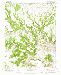
1972 Map of Cobert Mesa North
USGS Topo · Published 1975About this map
Cobert Mesa and Jesus Mesa dominate this portion of Las Animas County, showing a landscape defined by dramatic tablelands and deeply incised drainages. Published in 1975 from 1971-1972 field data, the map illustrates a network of seasonal water sources and canyons, including the prominent Cobert Canyon and Cottonwood Canyon. A series of Springs are mapped throughout the breaks, indicating the vital water points necessary for ranching in this arid environment. Significant landmarks like the Seven L Buttes and Brushy Mountain provided essential navigational markers for local travel. The presence of numerous Jeep Trails cutting through The Hogback and Steel Trap Canyon suggests a region of sparse settlement where movement followed the natural contours of the mesas and canyon floors.
Find a feature on this map
19 named features on this map. Tap any name to fly to it.
Don’t see what you’re looking for? This feature index may not catch every label — zoom into the map to look around manually.
Map Details
Editions of this 1972 Cobert Mesa North Map
This is the sole edition of this map. No revisions or reprints were ever made.
Other maps of this area

1891 · Mesa De Maya
USGS Topo · 1:125,000

1892 · Mt Carrizo
USGS Topo · 1:125,000

1893 · Mesa de Maya
USGS Topo · 1:125,000

1954 · Dalhart
USGS Topo · 1:250,000

1955 · La Junta
USGS Topo · 1:250,000

1958 · La Junta
USGS Topo · 1:250,000

1958 · Dalhart
USGS Topo · 1:250,000

1962 · Dalhart
USGS Topo · 1:250,000

1968 · La Junta
USGS Topo · 1:250,000

1972 · Travesser Park
USGS Topo · 1:24,000