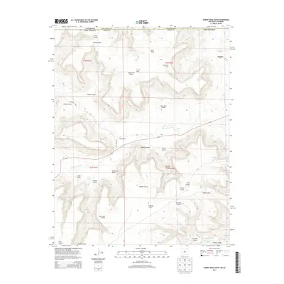
2013 Map of Cobert Mesa South
USGS Topo · Published 2013About this map
The Dry Cimarron River cuts through this high-altitude borderland where Colorado meets New Mexico. Dominating the upper elevations, Cobert Mesa provides a flat-topped contrast to the intricate system of drainages that define the local topography. This region is characterized by an extensive network of named canyons and draws, including the lengthy White Rock Canyon and Indian Trail Canyon, which suggest historical travel corridors through the breaks. Water sources are scarce but critical, evidenced by Gleason Springs and the drainage of Travesser Cr at the southern edge. The boundary line between Las Animas County and Union County follows the state line, marking a divide in land management and jurisdictional history. This 2013 survey illustrates how CO Highway B-036 and various local connectors navigate the complex terrain, connecting disparate ranches and landmarks like Horseshoe Draw and Giles Canyon in a landscape still shaped primarily by its natural relief.
Find a feature on this map
28 named features on this map. Tap any name to fly to it.
Don’t see what you’re looking for? This feature index may not catch every label — zoom into the map to look around manually.
Map Details
Editions of this 2013 Cobert Mesa South Map
This is the sole edition of this map. No revisions or reprints were ever made.
Other maps of this area

1891 · Mesa De Maya
USGS Topo · 1:125,000

1892 · Mt Carrizo
USGS Topo · 1:125,000

1893 · Mesa de Maya
USGS Topo · 1:125,000

1954 · Dalhart
USGS Topo · 1:250,000

1955 · La Junta
USGS Topo · 1:250,000

1958 · La Junta
USGS Topo · 1:250,000

1958 · Dalhart
USGS Topo · 1:250,000

1962 · Dalhart
USGS Topo · 1:250,000

1968 · La Junta
USGS Topo · 1:250,000

1972 · Travesser Park
USGS Topo · 1:24,000