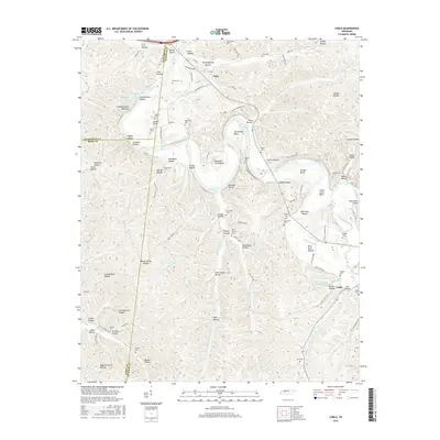
2016 Map of Coble
USGS Topo · Published 2016About this map
The Duck River meanders sharply through the heart of this Hickman County landscape, carving dramatic bends such as Horseshoe Bend and Burchard Town Bend. The settlement of Only sits just north of the river, while the community of Coble anchors the southeastern corner, connected by a network of rural roads like Coble To Only Rd. This area is characterized by a dense system of hollows, including Barren Hollow and Tarkiln Hollow, which have historically dictated the placement of small cemeteries and family plots. Genealogists will find a wealth of burial sites preserved here, such as King Cem, Blackwell Cem, and Wolf Creek Cem. Notable water features like Big Spring Lake Number Two and Blue Rock Shoals further define the local geography. The presence of the Grandmothers Building and numerous named bents and eddies along the river indicates a long-established relationship between the residents and the winding river corridor.
Find a feature on this map
117 named features on this map. Tap any name to fly to it.
Don’t see what you’re looking for? This feature index may not catch every label — zoom into the map to look around manually.
Map Details
Editions of this 2016 Coble Map
This is the sole edition of this map. No revisions or reprints were ever made.
Other maps of this area

1936 · Pleasantville
USGS Topo · 1:24,000

1936 · Hurricane Mills
USGS Topo · 1:24,000

1936 · Coble
USGS Topo · 1:24,000

1936 · Beaverdam Springs
USGS Topo · 1:24,000

1936 · Whitfield
USGS Topo · 1:24,000

1936 · Bucksnort
USGS Topo · 1:24,000

1936 · Chestnut Grove
USGS Topo · 1:24,000

1936 · Spot
USGS Topo · 1:24,000

1936 · Lobelville
USGS Topo · 1:24,000
1950 · Chestnut Grove
USGS Topo · 1:24,000