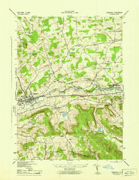
1945 Map of Cobleskill
USGS Topo · Published 1945About this map
Cobleskill serves as the primary hub of this mid-1940s survey, situated along the Delaware and Hudson railroad line and the Cobleskill Creek valley. The presence of the State Agricultural School on the western edge of town indicates the region's educational and agrarian focus during the wartime era. To the east, the subterranean tourism and geological interest of the area is highlighted by Howe Caverns and Secret Caverns, while the industrial output is noted at Klondike Quarry.
Find a feature on this map
55 named features on this map. Tap any name to fly to it.
Don’t see what you’re looking for? This feature index may not catch every label — zoom into the map to look around manually.
Map Details
Editions of this 1945 Cobleskill Map
This is the sole edition of this map. No revisions or reprints were ever made.
Other maps of this area

1896 · Fonda
USGS Topo · 1:62,500

1898 · Fonda
USGS Topo · 1:62,500

1898 · Canajoharie
USGS Topo · 1:62,500

1898 · Schoharie
USGS Topo · 1:62,500

1900 · Canajoharie
USGS Topo · 1:62,500

1900 · Schoharie
USGS Topo · 1:62,500

1900 · Schoharie
USGS Topo · 1:31,680

1902 · Canajoharie
USGS Topo · 1:62,500

1902 · Fonda
USGS Topo · 1:62,500

1904 · Richmondville
USGS Topo · 1:62,500