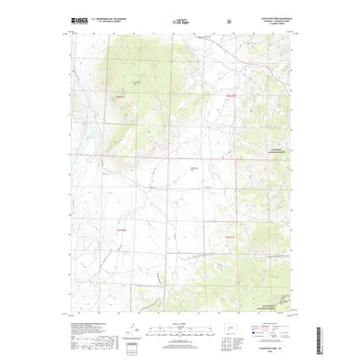
2019 Map of Cochetopa Park
USGS Topo · Published 2019About this map
Cochetopa Dome rises as a prominent geographic anchor in this high-altitude landscape within Saguache County. The map documents a complex drainage system where Cochetopa Cr and the waters of Lower Dome Reservoir meet various alpine watercourses, including Van Tassel Gulch and Wolverine Gulch. The terrain is defined by the crossing of the Continental Divide National Scenic Trail, which snakes through the southern reaches of Cochetopa Park and into the Cochetopa Hills.
Find a feature on this map
32 named features on this map. Tap any name to fly to it.
Don’t see what you’re looking for? This feature index may not catch every label — zoom into the map to look around manually.
Map Details
Editions of this 2019 Cochetopa Park Map
This is the sole edition of this map. No revisions or reprints were ever made.
Other maps of this area

1956 · Montrose
USGS Topo · 1:250,000

1959 · Montrose
USGS Topo · 1:250,000

1960 · Montrose
USGS Topo · 1:250,000

1962 · West Baldy
USGS Topo · 1:24,000

1962 · Razor Creek Dome
USGS Topo · 1:24,000
1962 · Sawtooth Mountain
USGS Topo · 1:24,000
1965 · Cold Spring Park
USGS Topo · 1:24,000
1965 · Elk Park
USGS Topo · 1:24,000
1967 · North Pass
USGS Topo · 1:24,000
1967 · Grouse Creek
USGS Topo · 1:24,000