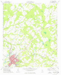
1974 Map of Cochran
USGS Topo · Published 1977About this map
The town of Cochran serves as the focal point of this mid-1970s survey, defined by its traditional grid and the presence of Middle Georgia College at the southern edge. The Southern railroad line cuts through the heart of the settlement, linking it to the wider region while local institutions like Cedar Hill Cem and the County Fairground anchor the community's social and historical landscape. To the north and east, the terrain shifts into a network of agricultural land and drainages, including the prominent Gum Swamp Creek and Bollinger Creek.
Find a feature on this map
38 named features on this map. Tap any name to fly to it.
Don’t see what you’re looking for? This feature index may not catch every label — zoom into the map to look around manually.
Map Details
Editions of this 1974 Cochran Map
This is the sole edition of this map. No revisions or reprints were ever made.
Other maps of this area

1956 · Cochran
USGS Topo · 1:62,500

1956 · Jeffersonville
USGS Topo · 1:62,500

1957 · Macon
USGS Topo · 1:250,000

1958 · Macon
USGS Topo · 1:250,000

1964 · Macon
USGS Topo · 1:250,000

1973 · Tarversville
USGS Topo · 1:24,000
1973 · Hawkinsville
USGS Topo · 1:24,000

1974 · Chester
USGS Topo · 1:24,000

1974 · Danville East
USGS Topo · 1:24,000
1974 · Yonkers
USGS Topo · 1:24,000