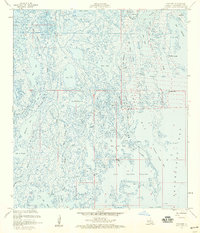
1957 Map of Cocodrie
USGS Topo · Published 1959About this map
Bay Sainte Elaine and the surrounding marshlands of Terrebonne Parish define this coastal environment during the mid-1950s. The landscape is a labyrinth of tidal channels and basins, including Deep Saline, Cocodrie Bayou, and Bay Sale. Industrial activity is evident throughout the wetlands, marked by a significant Gas Field and numerous Oil Wells and Sulphur Wells. This era shows a transition where the natural geography of Oyster Bayou and Crooked Bayou meets the growing infrastructure of the petroleum industry, connected by Coon Road and protected by a Levee. The presence of several Lights and a Radio Tower suggests the importance of navigation and communication in these complex waterways. Local landmarks like Cooke Point and Tambour Cutoff provide specific reference points for those tracing the history of Louisiana's changing coastline and its industrial development.
Find a feature on this map
47 named features on this map. Tap any name to fly to it.
Don’t see what you’re looking for? This feature index may not catch every label — zoom into the map to look around manually.
Map Details
Editions of this 1957 Cocodrie Map
3 editions found
Other maps of this area

1894 · Bayou De Large
USGS Topo · 1:62,500

1894 · Dulac
USGS Topo · 1:62,500

1935 · Cocodrie
USGS Topo · 1:31,680

1935 · Bourbeux
USGS Topo · 1:31,680

1935 · Lake Quitman
USGS Topo · 1:31,680

1940 · Bayou Du Large
USGS Topo · 1:62,500

1941 · Bayou Du Large
USGS Topo · 1:62,500

1941 · Dulac
USGS Topo · 1:62,500
1944 · Dulac
USGS Topo · 1:62,500

1944 · Bayou Du Large
USGS Topo · 1:62,500