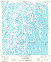
1957 Map of Cocodrie
USGS Topo · Published 1981About this map
Cocodrie serves as the primary outpost in this water-dominated landscape of southern Terrebonne Parish, situated where the Cocodrie Bayou meets a vast network of coastal marshes and tidal bays. The map documents an environment defined by its intricate hydrology, from the northern reach of Deep Saline to the coastal waters of Bay Sainte Elaine. The presence of numerous Oil Wells and a Sulphur Well indicates the significant industrial extraction efforts occurring within the wetlands during the mid-20th century.
Find a feature on this map
43 named features on this map. Tap any name to fly to it.
Don’t see what you’re looking for? This feature index may not catch every label — zoom into the map to look around manually.
Map Details
Editions of this 1957 Cocodrie Map
3 editions found
Other maps of this area

1894 · Bayou De Large
USGS Topo · 1:62,500

1894 · Dulac
USGS Topo · 1:62,500

1935 · Cocodrie
USGS Topo · 1:31,680

1935 · Bourbeux
USGS Topo · 1:31,680

1935 · Lake Quitman
USGS Topo · 1:31,680

1940 · Bayou Du Large
USGS Topo · 1:62,500

1941 · Bayou Du Large
USGS Topo · 1:62,500

1941 · Dulac
USGS Topo · 1:62,500
1944 · Dulac
USGS Topo · 1:62,500

1944 · Bayou Du Large
USGS Topo · 1:62,500