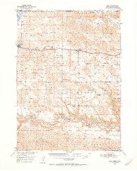
1950 Map of Cody
USGS Topo · Published 1952About this map
The Chicago and North Western railroad bisects this high plains landscape, connecting the Nebraska settlements of Cody and Nenzel as it follows the east-west corridor just south of the South Dakota state line. This 1950 survey reveals a ranching-centered economy where vast landholdings are identified by family names, including the Lindberg Ranch, Goodwin Ranch, and the Stasch Brothers Ranch. To the south, the terrain drops significantly into the breaks of the Niobrara River, where deep-cut drainages like Spring Canyon and McCann Canyon carve through the tableland toward the Barley Nebraska National Forest. The map also preserves the locations of vital rural institutions, such as Crackerbox Sch and Hinton Sch, which served the scattered homesteads before the further consolidation of local school districts.
Find a feature on this map
34 named features on this map. Tap any name to fly to it.
Don’t see what you’re looking for? This feature index may not catch every label — zoom into the map to look around manually.
Map Details
Editions of this 1950 Cody Map
2 editions found
Other maps of this area

1950 · Powderhorn Valley
USGS Topo · 1:62,500

1950 · Kennedy
USGS Topo · 1:62,500

1950 · Kilgore
USGS Topo · 1:62,500

1950 · Cody
USGS Topo · 1:62,500

1950 · Doughboy
USGS Topo · 1:62,500

1952 · Eli
USGS Topo · 1:62,500

1952 · Doughboy
USGS Topo · 1:62,500

1955 · Martin
USGS Topo · 1:250,000

1957 · Valentine
USGS Topo · 1:250,000

1958 · Martin
USGS Topo · 1:250,000