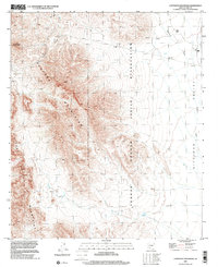
1996 Map of Coffeepot Mountain
USGS Topo · Published 2001About this map
Tohono O'Odham Indian Reservation lands dominate this mid-1990s survey, illustrating a landscape defined by sharp topographical rises and desert floor drainage. The Sauceda Mountains form a prominent central spine, anchored by the distinct peak of Coffeepot Mountain. Along the eastern edge, the topography descends into the Hickiwan Valley, where seasonal water flow is traced by the Hickiwan Wash. Settlement is sparse and focused on the northeastern reaches near Stoa Pitk. Here, the presence of a Cemetery and Graves suggests long-term localized habitation, while infrastructure like a Pipeline, a Water Tank, and a Drill Hole point to modern resource management. Southwest of the mountains, a Corral and a Guzzler mark the subtle human impact on this arid environment, providing essential context for land use and ranching history in Pima County.
Find a feature on this map
16 named features on this map. Tap any name to fly to it.
Don’t see what you’re looking for? This feature index may not catch every label — zoom into the map to look around manually.
Map Details
Editions of this 1996 Coffeepot Mountain Map
This is the sole edition of this map. No revisions or reprints were ever made.
Other maps of this area

1953 · Ajo
USGS Topo · 1:250,000

1957 · Ajo
USGS Topo · 1:250,000

1958 · Ajo
USGS Topo · 1:250,000

1958 · Kaka
USGS Topo · 1:62,500

1958 · Hat Mountain
USGS Topo · 1:62,500

1962 · Ajo
USGS Topo · 1:250,000

1963 · Ajo
USGS Topo · 1:250,000

1963 · Sikort Chuapo Mts
USGS Topo · 1:62,500

1963 · Cimarron Peak
USGS Topo · 1:62,500

1967 · Ajo
USGS Topo · 1:250,000