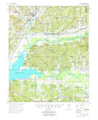
1955 Map of Coffeeville
USGS Topo · Published 1974About this map
Coffeeville serves as the focal point of this mid-century survey, situated at the junction of the Illinois Central Railroad and several regional roads. The landscape is dominated by the sprawling waters of Grenada Lake, a massive impoundment of the Yalobusha River and Skuna River. This hydraulic transformation is evident in the presence of Grenada Dam and landmarks such as Carver Point and Old Orchard Bay, which reflect the transition from riverine valley to reservoir. Away from the water, the terrain is dotted with small rural communities like Bruce Jct and Spearman. For genealogists, the map provides an exceptionally high density of rural landmarks, including the Indian Mound and numerous family-linked sites such as Hopewell Ch & Cem, Holissville Ch & Cem, and Martin Line Sch, documenting the social fabric of Yalobusha County before further modernization.
Find a feature on this map
97 named features on this map. Tap any name to fly to it.
Don’t see what you’re looking for? This feature index may not catch every label — zoom into the map to look around manually.
Map Details
Editions of this 1955 Coffeeville Map
2 editions found
Other maps of this area

1953 · Walthall
USGS Topo · 1:62,500

1953 · West Point
USGS Topo · 1:250,000

1954 · Pittsboro
USGS Topo · 1:62,500

1954 · Grenada
USGS Topo · 1:62,500

1954 · Duck Hill
USGS Topo · 1:62,500

1954 · McCarley
USGS Topo · 1:62,500

1954 · Oakland
USGS Topo · 1:62,500

1954 · Water Valley
USGS Topo · 1:62,500

1955 · Water Valley
USGS Topo · 1:62,500

1955 · Coffeeville
USGS Topo · 1:62,500