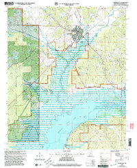
2000 Map of Coffeeville
USGS Topo · Published 2003About this map
Coffeeville serves as the focal point of this North Mississippi landscape, situated just north of the expansive Grenada Lake inundation. The terrain is a mix of protected timberland within the Holly Springs National Forest and the managed waters of the Skuna River basin. Genealogy researchers will find a high density of rural burial sites, including the Mt Myra Cem, Wildburn Cem, and Hairston Cem, which are scattered throughout the hills surrounding the lake. The map reflects the mid-century infrastructure changes brought by the Grenada Lake Reservation, which altered traditional land use and established recreation zones like the Skuna Turkey Creek Public Use Area. Transport and communication landmarks, such as the Yalobusha Lookout Tower and a local Landing Strip, further characterize the development of Yalobusha County at the turn of the millennium.
Find a feature on this map
36 named features on this map. Tap any name to fly to it.
Don’t see what you’re looking for? This feature index may not catch every label — zoom into the map to look around manually.
Map Details
Editions of this 2000 Coffeeville Map
This is the sole edition of this map. No revisions or reprints were ever made.
Other maps of this area

1953 · West Point
USGS Topo · 1:250,000

1954 · Grenada
USGS Topo · 1:62,500

1954 · Oakland
USGS Topo · 1:62,500

1954 · Water Valley
USGS Topo · 1:62,500

1955 · Water Valley
USGS Topo · 1:62,500

1955 · Coffeeville
USGS Topo · 1:62,500

1956 · Tupelo
USGS Topo · 1:250,000

1958 · Tupelo
USGS Topo · 1:250,000

1958 · West Point
USGS Topo · 1:250,000

1963 · West Point
USGS Topo · 1:250,000