
1955 Map of Coffeeville
USGS Topo · Published 1955About this map
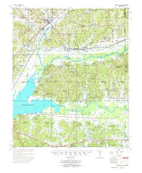
The Illinois Central railroad corridor anchors this mid-century survey of North Mississippi, passing through Coffeeville and near the rail junction at Bruce Jct. This era is defined by the transformation of the landscape under the Flood Control Act, most notably the rising waters of the Grenada Reservoir along the Yalobusha River and Skuna River. The map reveals a densely settled rural landscape where life centered on small communities like Gore Springs and Spearman, alongside dozens of family-named landmarks such as Arimount Cem and Jones Sch. Notable historical features include an Indian Mound near the river and the specialized boundaries of the Miss State Game & Fish Comm and Calhoun Co Refuge. The network of country roads remains tied to traditional river points, including Gums Crossing and Graysport Crossing, which provided vital transit before the reservoir's full expansion.
Find a feature on this map
103 named features on this map. Tap any name to fly to it.
Don’t see what you’re looking for? This feature index may not catch every label — zoom into the map to look around manually.
Map Details
Editions of this 1955 Coffeeville Map
2 editions found
Other maps of this area

1953 · Walthall
USGS Topo · 1:62,500

1953 · West Point
USGS Topo · 1:250,000

1954 · Pittsboro
USGS Topo · 1:62,500

1954 · Grenada
USGS Topo · 1:62,500

1954 · Duck Hill
USGS Topo · 1:62,500

1954 · McCarley
USGS Topo · 1:62,500

1954 · Oakland
USGS Topo · 1:62,500

1954 · Water Valley
USGS Topo · 1:62,500

1955 · Water Valley
USGS Topo · 1:62,500

1956 · Tupelo
USGS Topo · 1:250,000