1953 Map of Walthall
USGS Topo · Published 1953About this map
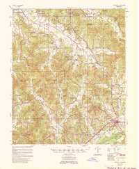
Walthall and the surrounding Webster County hill country appear here during the mid-1950s, revealing a landscape defined by small farming communities and a dense network of rural institutions. The topography is etched by the Sabougla Creek and Little Sand Creek drainages, where engineering projects like the Sabougla Canal and Bellefontaine Canal show mid-century efforts to manage the local watershed. Significant for genealogists, the map identifies dozens of country churches and family-named cemeteries, including Double Springs Ch & New Hope Cem and Macedonia Ch & Cem. The southern edge of the map is anchored by Eupora, where the Columbus and Greenville railroad line provided a vital connection to the wider region. Educational history is preserved through markers for the Doolittle Chapel Sch and Horse Pen Sch, while the historic Natchez Trace cuts through the northern portion of the county near Cadaretta.
Find a feature on this map
73 named features on this map. Tap any name to fly to it.
Don’t see what you’re looking for? This feature index may not catch every label — zoom into the map to look around manually.
Map Details
Editions of this 1953 Walthall Map
This is the sole edition of this map. No revisions or reprints were ever made.
Historical Maps of Eupora Through Time
1 maps found