
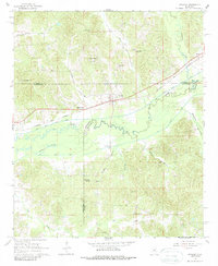
1966 Map of Stewart
USGS Topo · Published 1967About this map
The community of Stewart serves as the central hub of this mid-1960s survey, situated along the Columbus and Greenville railroad line. This interior Mississippi landscape is defined by the convergence of Webster, Montgomery, and Choctaw counties, where the natural meandering of the Big Black River meets the engineered precision of the Columbus and Greenville River Canal. The map reveals a dense network of country churches that anchored rural life, including Milligan Springs Ch, Serepta Ch, and New Prospect Ch.
Find a feature on this map
42 named features on this map. Tap any name to fly to it.
Don’t see what you’re looking for? This feature index may not catch every label — zoom into the map to look around manually.
Map Details
Editions of this 1966 Stewart Map
2 editions found
Other maps of this area

1953 · Walthall
USGS Topo · 1:62,500

1953 · West Point
USGS Topo · 1:250,000

1954 · Duck Hill
USGS Topo · 1:62,500

1958 · West Point
USGS Topo · 1:250,000

1963 · West Point
USGS Topo · 1:250,000

1966 · Kilmichael
USGS Topo · 1:24,000

1966 · Poplar Creek
USGS Topo · 1:24,000

1966 · Weir
USGS Topo · 1:24,000

1966 · Tomnolen
USGS Topo · 1:24,000

1966 · French Camp
USGS Topo · 1:24,000