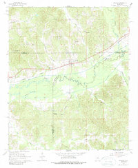
1966 Map of Stewart
USGS Topo · Published 1988About this map
Stewart sits at the heart of this mid-1960s landscape, serving as a key point on the Columbus and Greenville railroad. The terrain is defined by the complex drainage systems of the Big Black River and the Columbus and Greenville Canal, which cut through the lowlands where Big Slough and Jacks Slough also gather. The area is dense with community landmarks, particularly country churches like Piney Grove Ch and Serepta Ch, reflecting the rural social structure of Webster and Montgomery counties. This survey captures the intricate water management of the period, including the Bywy Ditch, and preserves the locations of numerous family and community sites like Thomson Cem and Williams Spring before modern changes altered these traditional rural boundaries.
Find a feature on this map
36 named features on this map. Tap any name to fly to it.
Don’t see what you’re looking for? This feature index may not catch every label — zoom into the map to look around manually.
Map Details
Editions of this 1966 Stewart Map
2 editions found
Other maps of this area

1953 · Walthall
USGS Topo · 1:62,500

1953 · West Point
USGS Topo · 1:250,000

1954 · Duck Hill
USGS Topo · 1:62,500

1958 · West Point
USGS Topo · 1:250,000

1963 · West Point
USGS Topo · 1:250,000

1966 · Kilmichael
USGS Topo · 1:24,000

1966 · Poplar Creek
USGS Topo · 1:24,000

1966 · Stewart
USGS Topo · 1:24,000

1966 · Weir
USGS Topo · 1:24,000

1966 · Tomnolen
USGS Topo · 1:24,000