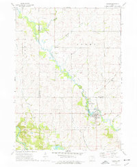
1973 Map of Coggon
USGS Topo · Published 1977About this map
Coggon stands at the junction of rail and river in this 1973 survey of the Linn and Delaware County line. The Illinois Central Gulf railroad cuts southeast through the landscape, passing the small settlement of Ehler and paralleling an old RR grade that hints at earlier transportation networks. The topography is defined by the winding course of Buffalo Creek, which is protected in part by the Buffalo Creek County Parkway north of town.
Find a feature on this map
31 named features on this map. Tap any name to fly to it.
Don’t see what you’re looking for? This feature index may not catch every label — zoom into the map to look around manually.
Map Details
Editions of this 1973 Coggon Map
This is the sole edition of this map. No revisions or reprints were ever made.
Other maps of this area

1888 · Marion
USGS Topo · 1:62,500

1889 · Marion
USGS Topo · 1:62,500

1890 · Anamosa
USGS Topo · 1:62,500

1900 · Anamosa
USGS Topo · 1:125,000

1903 · Winthrop
USGS Topo · 1:125,000

1959 · Dubuque
USGS Topo · 1:250,000

1961 · Dubuque
USGS Topo · 1:250,000

1962 · Dubuque
USGS Topo · 1:250,000
1968 · Central City
USGS Topo · 1:24,000
1968 · Lafayette
USGS Topo · 1:24,000