1968 Map of Central City
USGS Topo · Published 1970About this map
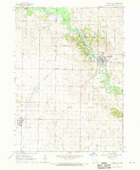
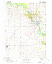
The Wapsipinicon River carves a winding path through this Linn County landscape, serving as the focal point for both recreation and settlement in the late 1960s. The community of Central City sits at the river's bend, where the Illinois Central railroad intersects the town's grid. To the west, the river corridor is preserved within Pinicon Ridge County Park, which features an observation tower, campgrounds, and several picnic areas.
Find a feature on this map
33 named features on this map. Tap any name to fly to it.
Don’t see what you’re looking for? This feature index may not catch every label — zoom into the map to look around manually.
Map Details
Editions of this 1968 Central City Map
2 editions found
Other maps of this area

1888 · Marion
USGS Topo · 1:62,500

1889 · Marion
USGS Topo · 1:62,500

1890 · Anamosa
USGS Topo · 1:62,500

1900 · Anamosa
USGS Topo · 1:125,000

1903 · Winthrop
USGS Topo · 1:125,000

1959 · Dubuque
USGS Topo · 1:250,000

1961 · Dubuque
USGS Topo · 1:250,000

1962 · Dubuque
USGS Topo · 1:250,000
1967 · Cedar Rapids North
USGS Topo · 1:24,000

1968 · Lafayette
USGS Topo · 1:24,000