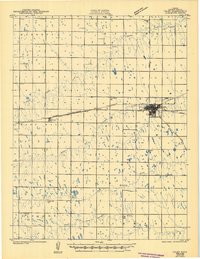
1967 Map of Colby
USGS Topo · Published 1968About this map
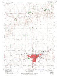
Colby serves as a significant High Plains hub on this 1960s survey, showing a well-established grid defined by the convergence of the Union Pacific and Chicago Rock Island and Pacific railroads. The town center is densely marked with civic institutions including the Courthouse, St Thomas Hospital, and several parks like Fike Park and Young Park. Education and research are central to the area's character, evidenced by the presence of Colby Junior College and the Kansas State University Experiment Station on the western edge of town.
Find a feature on this map
25 named features on this map. Tap any name to fly to it.
Don’t see what you’re looking for? This feature index may not catch every label — zoom into the map to look around manually.
Map Details
Editions of this 1967 Colby Map
This is the sole edition of this map. No revisions or reprints were ever made.
Historical Maps of Colby Through Time
7 maps found