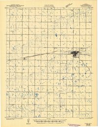
1943 Map of Colby
USGS Topo · Published 1949About this map
The High Plains of Thomas County at the height of World War II are defined by a strictly surveyed grid of section lines and the vital passage of two major transcontinental railroads. Colby serves as the regional hub where the Union Pacific and the Chicago Rock Island and Pacific converge, creating a vital junction for the agricultural economy. The landscape is punctuated by a network of one-room schoolhouses that served the surrounding farmstead townships, including Abilene Sch, Lone Willow Sch, and the descriptively named Soddy Sch in the southern reaches of the quadrangle. While US Highway No 24 and State Highway No 25 facilitate regional travel, the underlying drainage of the South Fork Solomon River and Prairie Dog Creek provides the only break in the geometric regularity of the prairie, marking the seasonal watercourses essential to early settlement.
Find a feature on this map
30 named features on this map. Tap any name to fly to it.
Don’t see what you’re looking for? This feature index may not catch every label — zoom into the map to look around manually.
Map Details
Editions of this 1943 Colby Map
2 editions found
Other maps of this area

1943 · Colby
USGS Topo · 1:62,500

1951 · Achilles
USGS Topo · 1:62,500

1951 · Chardon
USGS Topo · 1:62,500

1951 · Dewey Ranch
USGS Topo · 1:62,500

1954 · Goodland
USGS Topo · 1:250,000

1956 · Goodland
USGS Topo · 1:250,000

1957 · Goodland
USGS Topo · 1:250,000

1966 · Brewster SE
USGS Topo · 1:24,000

1967 · Brewster NE
USGS Topo · 1:24,000

1967 · Colby SE
USGS Topo · 1:24,000