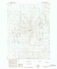
1983 Map of Cold Bay B-1
USGS Topo · Published 1983About this map
The Aghileen Pinnacles rise as a striking geological landmark within this 1983 survey of the Alaska Peninsula, marking the divide between the Izembek National Wildlife Refuge and the Alaska Peninsula National Wildlife Refuge. The landscape is dominated by volcanic features and glacial drainage patterns, centered on the prominent Mount Emmons and the adjacent Emmons Lake.
Find a feature on this map
14 named features on this map. Tap any name to fly to it.
Don’t see what you’re looking for? This feature index may not catch every label — zoom into the map to look around manually.
Map Details
Editions of this 1983 Cold Bay B-1 Map
This is the sole edition of this map. No revisions or reprints were ever made.
Other maps of this area

1943 · Fort Randall
USGS Topo · 1:250,000

1949 · Fort Randall
USGS Topo · 1:250,000

1950 · Fort Randall
USGS Topo · 1:250,000

1953 · Port Moller
USGS Topo · 1:250,000

1963 · Port Moller C-6
USGS Topo · 1:63,360

1963 · Port Moller A-6
USGS Topo · 1:63,360
1963 · Cold Bay C-2
USGS Topo · 1:63,360
1963 · Cold Bay C-1
USGS Topo · 1:63,360

1983 · Port Moller B-6
USGS Topo · 1:63,360
1983 · Cold Bay A-1
USGS Topo · 1:63,360