1983 Map of Cold Bay A-1
USGS Topo · Published 1983About this map
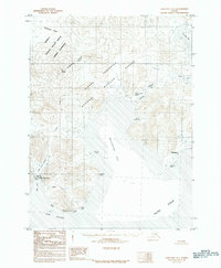
Mount Dutton dominates the landscape of the western Alaska Peninsula, overlooking a coastal environment defined by protected waters and seasonal harbors. Coastal settlements like King Cove and Belkofski anchor the shoreline, with the latter featuring a local Cem and Belkofski Point. The map illustrates the specialized maritime infrastructure of the early 1980s, including the Landing Strip near Delta Creek and protected mooring areas at Kitchen Anchorage and Captain Harbor. Much of the interior is designated within the Izembec National Wildlife Refuge and the Alaska Peninsula National Wildlife Refuge, highlighting the region's role as a protected wilderness. Distinctive landmarks such as Indian Head, Slavna Point, and Table Rock serve as essential navigational markers for those traversing the Pacific Ocean and Deer Passage.
Find a feature on this map
33 named features on this map. Tap any name to fly to it.
Don’t see what you’re looking for? This feature index may not catch every label — zoom into the map to look around manually.
Map Details
Editions of this 1983 Cold Bay A-1 Map
2 editions found
Historical Maps of King Cove Through Time
384 maps found

1944 Cold Bay Sheet No. 1 of 25
Aleutians East Borough, AK

1944 Cold Bay Sheet No. 20 of 25
Aleutians East Borough, AK

1944 Cold Bay Sheet No. 2 of 25
Aleutians East Borough, AK

1949 Fort Randall
Aleutians East Borough, AK

1950 Fort Randall
Aleutians East Borough, AK

1951 Unimak
Aleutians East Borough, AK

1953 Port Moller
Aleutians East Borough, AK

1955 Beechey Point B-5
Aleutians East Borough, AK

1958 Unimak
Aleutians East Borough, AK

1958 Unimak B-2 NE
Aleutians East Borough, AK

1963 Chignik A-6
Aleutians East Borough, AK

1963 Chignik A-7
Aleutians East Borough, AK

1963 Chignik A-8
Aleutians East Borough, AK

1963 Chignik B-7
Aleutians East Borough, AK

1963 Chignik C-5
Aleutians East Borough, AK

1963 Chignik C-6
Aleutians East Borough, AK

1963 Chignik D-4
Aleutians East Borough, AK

1963 Cold Bay B-3
Aleutians East Borough, AK

1963 Cold Bay B-4
Aleutians East Borough, AK

1963 Cold Bay C-1
Aleutians East Borough, AK

1963 Cold Bay C-2
Aleutians East Borough, AK

1963 Cold Bay D-1
Aleutians East Borough, AK

1963 False Pass C-1
Aleutians East Borough, AK

1963 False Pass C-2
Aleutians East Borough, AK

1963 False Pass D-0
Aleutians East Borough, AK

1963 False Pass D-1
Aleutians East Borough, AK

1963 False Pass D-2
Aleutians East Borough, AK

1963 False Pass D-3
Aleutians East Borough, AK

1963 Port Moller A-1
Aleutians East Borough, AK

1963 Port Moller A-2
Aleutians East Borough, AK

1963 Port Moller A-3
Aleutians East Borough, AK

1963 Port Moller A-4
Aleutians East Borough, AK

1963 Port Moller A-5
Aleutians East Borough, AK

1963 Port Moller A-6
Aleutians East Borough, AK

1963 Port Moller B-1
Aleutians East Borough, AK

1963 Port Moller B-2
Aleutians East Borough, AK

1963 Port Moller C-1
Aleutians East Borough, AK

1963 Port Moller C-2
Aleutians East Borough, AK

1963 Port Moller C-5
Aleutians East Borough, AK

1963 Port Moller C-6
Aleutians East Borough, AK

1963 Port Moller D-1
Aleutians East Borough, AK

1963 Port Moller D-2
Aleutians East Borough, AK

1963 Port Moller D-3
Aleutians East Borough, AK

1963 Port Moller D-4
Aleutians East Borough, AK

1963 Port Moller D-5
Aleutians East Borough, AK

1963 Port Moller D-6
Aleutians East Borough, AK

1963 Simeonof Island
Aleutians East Borough, AK

1963 Simeonof Island D-1
Aleutians East Borough, AK

1963 Simeonof Island D-2
Aleutians East Borough, AK

1963 Simeonof Island D-3
Aleutians East Borough, AK

1963 Simeonof Island D-4
Aleutians East Borough, AK

1963 Stepovak Bay A-5
Aleutians East Borough, AK

1963 Stepovak Bay A-6
Aleutians East Borough, AK

1963 Stepovak Bay B-6
Aleutians East Borough, AK

1963 Stepovak Bay C-5 and C-6
Aleutians East Borough, AK

1963 Stepovak Bay D-6
Aleutians East Borough, AK

1967 Simeonof Island
Aleutians East Borough, AK

1983 Cold Bay A-1
Aleutians East Borough, AK

1983 Cold Bay B-1
Aleutians East Borough, AK

1983 Port Moller B-3
Aleutians East Borough, AK

1983 Port Moller B-4
Aleutians East Borough, AK

1983 Port Moller B-5
Aleutians East Borough, AK

1983 Port Moller B-6
Aleutians East Borough, AK

1983 Port Moller C-3
Aleutians East Borough, AK

1983 Port Moller C-4
Aleutians East Borough, AK

1988 Port Moller
Aleutians East Borough, AK

1989 Cold Bay A-6
Aleutians East Borough, AK

1989 False Pass B-2
Aleutians East Borough, AK

1989 False Pass B-3
Aleutians East Borough, AK

1989 False Pass C-4
Aleutians East Borough, AK

1989 False Pass C-5
Aleutians East Borough, AK

1989 False Pass C-6
Aleutians East Borough, AK

1989 False Pass D-6
Aleutians East Borough, AK

1989 Unalaska D-1
Aleutians East Borough, AK

1989 Unimak A-3
Aleutians East Borough, AK

1989 Unimak A-4
Aleutians East Borough, AK

1989 Unimak A-5
Aleutians East Borough, AK

1989 Unimak A-6
Aleutians East Borough, AK

1989 Unimak B-2
Aleutians East Borough, AK

1989 Unimak B-3
Aleutians East Borough, AK

1989 Unimak B-5
Aleutians East Borough, AK

1989 Unimak B-6
Aleutians East Borough, AK

1989 Unimak C-1
Aleutians East Borough, AK

1989 Unimak C-2
Aleutians East Borough, AK

1989 Unimak C-3
Aleutians East Borough, AK

1989 Unimak D-1
Aleutians East Borough, AK

1989 Unimak D-2
Aleutians East Borough, AK

1995 Cold Bay A-2
Aleutians East Borough, AK

1995 Cold Bay A-3
Aleutians East Borough, AK

1995 Cold Bay A-4
Aleutians East Borough, AK

1995 Cold Bay A-5
Aleutians East Borough, AK

1995 Cold Bay B-2
Aleutians East Borough, AK

1995 False Pass D-4
Aleutians East Borough, AK

1995 False Pass D-5
Aleutians East Borough, AK

2017 Sitka A-1 NW
Aleutians East Borough, AK

2020 Chignik A-6 NW
Aleutians East Borough, AK

2020 Chignik A-6 SW
Aleutians East Borough, AK

2020 Chignik A-7 NE
Aleutians East Borough, AK

2020 Chignik A-7 NW
Aleutians East Borough, AK

2020 Chignik A-7 SE
Aleutians East Borough, AK

2020 Chignik A-7 SW
Aleutians East Borough, AK

2020 Chignik A-8 NE
Aleutians East Borough, AK

2020 Chignik A-8 SE
Aleutians East Borough, AK

2020 Chignik B-6 NW
Aleutians East Borough, AK

2020 Chignik B-6 SW
Aleutians East Borough, AK

2020 Chignik B-7 NE
Aleutians East Borough, AK

2020 Chignik B-7 NW
Aleutians East Borough, AK

2020 Chignik B-7 OE W SW
Aleutians East Borough, AK

2020 Chignik B-7 SE
Aleutians East Borough, AK

2020 Chignik B-7 SW
Aleutians East Borough, AK

2020 Chignik C-4 NW
Aleutians East Borough, AK

2020 Chignik C-5 NE
Aleutians East Borough, AK

2020 Chignik C-5 NW
Aleutians East Borough, AK

2020 Chignik C-6 SE
Aleutians East Borough, AK

2020 Chignik C-6 SW
Aleutians East Borough, AK

2020 Chignik D-4 SE
Aleutians East Borough, AK

2020 Chignik D-4 SW
Aleutians East Borough, AK

2020 Cold Bay A-1 NE
Aleutians East Borough, AK

2020 Cold Bay A-1 NW
Aleutians East Borough, AK

2020 Cold Bay A-1 SE
Aleutians East Borough, AK

2020 Cold Bay A-1 SW
Aleutians East Borough, AK

2020 Cold Bay A-2 NE
Aleutians East Borough, AK

2020 Cold Bay A-2 NW
Aleutians East Borough, AK

2020 Cold Bay A-2 SE
Aleutians East Borough, AK

2020 Cold Bay A-2 SW
Aleutians East Borough, AK

2020 Cold Bay A-3 NE
Aleutians East Borough, AK

2020 Cold Bay A-3 NW
Aleutians East Borough, AK

2020 Cold Bay A-3 SE
Aleutians East Borough, AK

2020 Cold Bay A-3 SW
Aleutians East Borough, AK

2020 Cold Bay A-4 NE
Aleutians East Borough, AK

2020 Cold Bay A-4 NW
Aleutians East Borough, AK

2020 Cold Bay A-4 SE
Aleutians East Borough, AK

2020 Cold Bay A-4 SW
Aleutians East Borough, AK

2020 Cold Bay A-5 SE
Aleutians East Borough, AK

2020 Cold Bay A-5 SW
Aleutians East Borough, AK

2020 Cold Bay A-6 SE
Aleutians East Borough, AK

2020 Cold Bay A-6 SW
Aleutians East Borough, AK

2020 Cold Bay B-1 NE
Aleutians East Borough, AK

2020 Cold Bay B-1 NW
Aleutians East Borough, AK

2020 Cold Bay B-1 SE
Aleutians East Borough, AK

2020 Cold Bay B-1 SW
Aleutians East Borough, AK

2020 Cold Bay B-2 NE
Aleutians East Borough, AK

2020 Cold Bay B-2 NW
Aleutians East Borough, AK

2020 Cold Bay B-2 SE
Aleutians East Borough, AK

2020 Cold Bay B-2 SW
Aleutians East Borough, AK

2020 Cold Bay B-3 NE
Aleutians East Borough, AK

2020 Cold Bay B-3 SE
Aleutians East Borough, AK

2020 Cold Bay B-3 SW
Aleutians East Borough, AK

2020 Cold Bay B-4 NE
Aleutians East Borough, AK

2020 Cold Bay B-4 NW
Aleutians East Borough, AK

2020 Cold Bay C-1 NE
Aleutians East Borough, AK

2020 Cold Bay C-1 NW
Aleutians East Borough, AK

2020 Cold Bay C-1 SE
Aleutians East Borough, AK

2020 Cold Bay C-1 SW
Aleutians East Borough, AK

2020 Cold Bay C-2 SE
Aleutians East Borough, AK

2020 Cold Bay D-1 SE
Aleutians East Borough, AK

2020 False Pass B-2 NE
Aleutians East Borough, AK

2020 False Pass B-2 NW
Aleutians East Borough, AK

2020 False Pass B-2 SE
Aleutians East Borough, AK

2020 False Pass B-2 SW
Aleutians East Borough, AK

2020 False Pass B-3 NE
Aleutians East Borough, AK

2020 False Pass B-3 NW
Aleutians East Borough, AK

2020 False Pass B-3 SE
Aleutians East Borough, AK

2020 False Pass B-3 SW
Aleutians East Borough, AK

2020 False Pass B-4 SE
Aleutians East Borough, AK

2020 False Pass C-1 NE
Aleutians East Borough, AK

2020 False Pass C-1 NW
Aleutians East Borough, AK

2020 False Pass C-1 SE
Aleutians East Borough, AK

2020 False Pass C-1 SW
Aleutians East Borough, AK

2020 False Pass C-2 NE
Aleutians East Borough, AK

2020 False Pass C-2 SE
Aleutians East Borough, AK

2020 False Pass C-3 NW
Aleutians East Borough, AK

2020 False Pass C-3 SE
Aleutians East Borough, AK

2020 False Pass C-3 SW
Aleutians East Borough, AK

2020 False Pass C-4 NE
Aleutians East Borough, AK

2020 False Pass C-4 NW
Aleutians East Borough, AK

2020 False Pass C-5 NE
Aleutians East Borough, AK

2020 False Pass C-5 NW
Aleutians East Borough, AK

2020 False Pass C-5 SE
Aleutians East Borough, AK

2020 False Pass C-5 SW
Aleutians East Borough, AK

2020 False Pass C-6 NE
Aleutians East Borough, AK

2020 False Pass C-6 NW
Aleutians East Borough, AK

2020 False Pass D-0 NE
Aleutians East Borough, AK

2020 False Pass D-0 NW
Aleutians East Borough, AK

2020 False Pass D-0 OE E NW
Aleutians East Borough, AK

2020 False Pass D-0 OE E SW
Aleutians East Borough, AK

2020 False Pass D-0 SE
Aleutians East Borough, AK

2020 False Pass D-0 SW
Aleutians East Borough, AK

2020 False Pass D-1 NE
Aleutians East Borough, AK

2020 False Pass D-1 NW
Aleutians East Borough, AK

2020 False Pass D-1 SE
Aleutians East Borough, AK

2020 False Pass D-1 SW
Aleutians East Borough, AK

2020 False Pass D-2 NE
Aleutians East Borough, AK

2020 False Pass D-2 NW
Aleutians East Borough, AK

2020 False Pass D-2 SE
Aleutians East Borough, AK

2020 False Pass D-2 SW
Aleutians East Borough, AK

2020 False Pass D-3 NE
Aleutians East Borough, AK

2020 False Pass D-3 NW
Aleutians East Borough, AK

2020 False Pass D-3 SE
Aleutians East Borough, AK

2020 False Pass D-4 NE
Aleutians East Borough, AK

2020 False Pass D-4 NW
Aleutians East Borough, AK

2020 False Pass D-4 SE
Aleutians East Borough, AK

2020 False Pass D-4 SW
Aleutians East Borough, AK

2020 False Pass D-5 NE
Aleutians East Borough, AK

2020 False Pass D-5 NW
Aleutians East Borough, AK

2020 False Pass D-5 SE
Aleutians East Borough, AK

2020 False Pass D-5 SW
Aleutians East Borough, AK

2020 False Pass D-6 NE
Aleutians East Borough, AK

2020 False Pass D-6 NW
Aleutians East Borough, AK

2020 False Pass D-6 SE
Aleutians East Borough, AK

2020 False Pass D-6 SW
Aleutians East Borough, AK

2020 Port Moller A-1 NE
Aleutians East Borough, AK

2020 Port Moller A-1 NW
Aleutians East Borough, AK

2020 Port Moller A-1 SE
Aleutians East Borough, AK

2020 Port Moller A-1 SW
Aleutians East Borough, AK

2020 Port Moller A-2 NE
Aleutians East Borough, AK

2020 Port Moller A-2 NW
Aleutians East Borough, AK

2020 Port Moller A-2 SW
Aleutians East Borough, AK

2020 Port Moller A-3 NE
Aleutians East Borough, AK

2020 Port Moller A-3 NW
Aleutians East Borough, AK

2020 Port Moller A-3 SE
Aleutians East Borough, AK

2020 Port Moller A-4 NE
Aleutians East Borough, AK

2020 Port Moller A-4 NW
Aleutians East Borough, AK

2020 Port Moller A-5 NE
Aleutians East Borough, AK

2020 Port Moller A-5 NW
Aleutians East Borough, AK

2020 Port Moller A-5 SE
Aleutians East Borough, AK

2020 Port Moller A-5 SW
Aleutians East Borough, AK

2020 Port Moller A-6 NE
Aleutians East Borough, AK

2020 Port Moller A-6 NW
Aleutians East Borough, AK

2020 Port Moller A-6 SE
Aleutians East Borough, AK

2020 Port Moller A-6 SW
Aleutians East Borough, AK

2020 Port Moller B-1 NE
Aleutians East Borough, AK

2020 Port Moller B-1 NW
Aleutians East Borough, AK

2020 Port Moller B-1 SE
Aleutians East Borough, AK

2020 Port Moller B-1 SW
Aleutians East Borough, AK

2020 Port Moller B-2 NE
Aleutians East Borough, AK

2020 Port Moller B-2 NW
Aleutians East Borough, AK

2020 Port Moller B-2 SE
Aleutians East Borough, AK

2020 Port Moller B-2 SW
Aleutians East Borough, AK

2020 Port Moller B-3 NE
Aleutians East Borough, AK

2020 Port Moller B-3 NW
Aleutians East Borough, AK

2020 Port Moller B-3 SE
Aleutians East Borough, AK

2020 Port Moller B-3 SW
Aleutians East Borough, AK

2020 Port Moller B-4 NE
Aleutians East Borough, AK

2020 Port Moller B-4 NW
Aleutians East Borough, AK

2020 Port Moller B-4 SE
Aleutians East Borough, AK

2020 Port Moller B-4 SW
Aleutians East Borough, AK

2020 Port Moller B-5 NE
Aleutians East Borough, AK

2020 Port Moller B-5 NW
Aleutians East Borough, AK

2020 Port Moller B-5 SE
Aleutians East Borough, AK

2020 Port Moller B-5 SW
Aleutians East Borough, AK

2020 Port Moller B-6 NE
Aleutians East Borough, AK

2020 Port Moller B-6 NW
Aleutians East Borough, AK

2020 Port Moller B-6 SE
Aleutians East Borough, AK

2020 Port Moller B-6 SW
Aleutians East Borough, AK

2020 Port Moller C-1 NE
Aleutians East Borough, AK

2020 Port Moller C-1 NW
Aleutians East Borough, AK

2020 Port Moller C-1 SE
Aleutians East Borough, AK

2020 Port Moller C-2 NE
Aleutians East Borough, AK

2020 Port Moller C-2 NW
Aleutians East Borough, AK

2020 Port Moller C-2 SE
Aleutians East Borough, AK

2020 Port Moller C-2 SW
Aleutians East Borough, AK

2020 Port Moller C-3 NE
Aleutians East Borough, AK

2020 Port Moller C-3 NW
Aleutians East Borough, AK

2020 Port Moller C-3 SE
Aleutians East Borough, AK

2020 Port Moller C-3 SW
Aleutians East Borough, AK

2020 Port Moller C-4 NE
Aleutians East Borough, AK

2020 Port Moller C-4 NW
Aleutians East Borough, AK

2020 Port Moller C-4 SE
Aleutians East Borough, AK

2020 Port Moller C-4 SW
Aleutians East Borough, AK

2020 Port Moller C-5 NE
Aleutians East Borough, AK

2020 Port Moller C-5 NW
Aleutians East Borough, AK

2020 Port Moller C-5 SE
Aleutians East Borough, AK

2020 Port Moller C-5 SW
Aleutians East Borough, AK

2020 Port Moller C-6 NE
Aleutians East Borough, AK

2020 Port Moller C-6 NW
Aleutians East Borough, AK

2020 Port Moller C-6 SE
Aleutians East Borough, AK

2020 Port Moller C-6 SW
Aleutians East Borough, AK

2020 Port Moller D-1 NE
Aleutians East Borough, AK

2020 Port Moller D-1 NW
Aleutians East Borough, AK

2020 Port Moller D-1 SE
Aleutians East Borough, AK

2020 Port Moller D-1 SW
Aleutians East Borough, AK

2020 Port Moller D-2 NE
Aleutians East Borough, AK

2020 Port Moller D-2 NW
Aleutians East Borough, AK

2020 Port Moller D-2 SE
Aleutians East Borough, AK

2020 Port Moller D-2 SW
Aleutians East Borough, AK

2020 Port Moller D-3 NE
Aleutians East Borough, AK

2020 Port Moller D-3 NW
Aleutians East Borough, AK

2020 Port Moller D-3 OE N SE
Aleutians East Borough, AK

2020 Port Moller D-3 OE N SW
Aleutians East Borough, AK

2020 Port Moller D-3 SE
Aleutians East Borough, AK

2020 Port Moller D-3 SW
Aleutians East Borough, AK

2020 Port Moller D-4 NE
Aleutians East Borough, AK

2020 Port Moller D-4 NW
Aleutians East Borough, AK

2020 Port Moller D-4 OE N SE
Aleutians East Borough, AK

2020 Port Moller D-4 OE N SW
Aleutians East Borough, AK

2020 Port Moller D-4 SE
Aleutians East Borough, AK

2020 Port Moller D-4 SW
Aleutians East Borough, AK

2020 Port Moller D-5 NE
Aleutians East Borough, AK

2020 Port Moller D-5 NW
Aleutians East Borough, AK

2020 Port Moller D-5 SE
Aleutians East Borough, AK

2020 Port Moller D-5 SW
Aleutians East Borough, AK

2020 Port Moller D-6 NE
Aleutians East Borough, AK

2020 Port Moller D-6 NW
Aleutians East Borough, AK

2020 Port Moller D-6 SE
Aleutians East Borough, AK

2020 Port Moller D-6 SW
Aleutians East Borough, AK

2020 Simeonof Island D-1 NW
Aleutians East Borough, AK

2020 Simeonof Island D-1 SW
Aleutians East Borough, AK

2020 Simeonof Island D-2 NE
Aleutians East Borough, AK

2020 Simeonof Island D-2 SW
Aleutians East Borough, AK

2020 Simeonof Island D-3 NW
Aleutians East Borough, AK

2020 Simeonof Island D-3 SE
Aleutians East Borough, AK

2020 Simeonof Island D-4 NE
Aleutians East Borough, AK

2020 Simeonof Island D-4 NW
Aleutians East Borough, AK

2020 Simeonof Island D-4 SW
Aleutians East Borough, AK

2020 Stepovak Bay A-5 NE
Aleutians East Borough, AK

2020 Stepovak Bay A-5 NW
Aleutians East Borough, AK

2020 Stepovak Bay A-5 OE E SW
Aleutians East Borough, AK

2020 Stepovak Bay A-5 OE N SW
Aleutians East Borough, AK

2020 Stepovak Bay A-5 SE
Aleutians East Borough, AK

2020 Stepovak Bay A-5 SW
Aleutians East Borough, AK

2020 Stepovak Bay A-6 NE
Aleutians East Borough, AK

2020 Stepovak Bay A-6 NW
Aleutians East Borough, AK

2020 Stepovak Bay A-6 SE
Aleutians East Borough, AK

2020 Stepovak Bay A-6 SW
Aleutians East Borough, AK

2020 Stepovak Bay B-6 SW
Aleutians East Borough, AK

2020 Stepovak Bay C-5 NW
Aleutians East Borough, AK

2020 Stepovak Bay C-5 SW
Aleutians East Borough, AK

2020 Stepovak Bay C-6 NE
Aleutians East Borough, AK

2020 Stepovak Bay C-6 SE
Aleutians East Borough, AK

2020 Stepovak Bay D-5 SW
Aleutians East Borough, AK

2020 Stepovak Bay D-6 NW
Aleutians East Borough, AK

2020 Stepovak Bay D-6 SE
Aleutians East Borough, AK

2020 Stepovak Bay D-6 SW
Aleutians East Borough, AK

2020 Unalaska C-1 NE
Aleutians East Borough, AK

2020 Unalaska D-1 NE
Aleutians East Borough, AK

2020 Unalaska D-1 SE
Aleutians East Borough, AK

2020 Unalaska D-1 SW
Aleutians East Borough, AK

2020 Unimak A-3 NE
Aleutians East Borough, AK

2020 Unimak A-3 SW
Aleutians East Borough, AK

2020 Unimak A-4 NE
Aleutians East Borough, AK

2020 Unimak A-4 NW
Aleutians East Borough, AK

2020 Unimak A-4 SE
Aleutians East Borough, AK

2020 Unimak A-4 SW
Aleutians East Borough, AK

2020 Unimak A-5 NE
Aleutians East Borough, AK

2020 Unimak A-5 NW
Aleutians East Borough, AK

2020 Unimak A-5 SE
Aleutians East Borough, AK

2020 Unimak A-5 SW
Aleutians East Borough, AK

2020 Unimak A-6 NE
Aleutians East Borough, AK

2020 Unimak A-6 NW
Aleutians East Borough, AK

2020 Unimak A-6 SE
Aleutians East Borough, AK

2020 Unimak A-6 SW
Aleutians East Borough, AK

2020 Unimak B-2 NW
Aleutians East Borough, AK

2020 Unimak B-2 OE E NW
Aleutians East Borough, AK

2020 Unimak B-5 SE
Aleutians East Borough, AK

2020 Unimak B-5 SW
Aleutians East Borough, AK

2020 Unimak B-6 SE
Aleutians East Borough, AK

2021 Sitka A-1 NW
Aleutians East Borough, AK

2021 Unimak A-3 NW
Aleutians East Borough, AK

2021 Unimak B-2 NE
Aleutians East Borough, AK

2021 Unimak B-3 NE
Aleutians East Borough, AK

2021 Unimak B-3 NW
Aleutians East Borough, AK

2021 Unimak C-1 NE
Aleutians East Borough, AK

2021 Unimak C-1 NW
Aleutians East Borough, AK

2021 Unimak C-1 SE
Aleutians East Borough, AK

2021 Unimak C-1 SW
Aleutians East Borough, AK

2021 Unimak C-2 NE
Aleutians East Borough, AK

2021 Unimak C-2 NW
Aleutians East Borough, AK

2021 Unimak C-2 SE
Aleutians East Borough, AK

2021 Unimak C-2 SW
Aleutians East Borough, AK

2021 Unimak C-3 NE
Aleutians East Borough, AK

2021 Unimak C-3 NW
Aleutians East Borough, AK

2021 Unimak C-3 SE
Aleutians East Borough, AK

2021 Unimak C-3 SW
Aleutians East Borough, AK

2021 Unimak D-1 NE
Aleutians East Borough, AK

2021 Unimak D-1 NW
Aleutians East Borough, AK

2021 Unimak D-1 SE
Aleutians East Borough, AK

2021 Unimak D-1 SW
Aleutians East Borough, AK

2021 Unimak D-2 NE
Aleutians East Borough, AK

2021 Unimak D-2 NW
Aleutians East Borough, AK

2021 Unimak D-2 SE
Aleutians East Borough, AK

2021 Unimak D-2 SW
Aleutians East Borough, AK

2023 Port Moller A-2 NW
Aleutians East Borough, AK

2024 Sitka A-1 NW
Aleutians East Borough, AK