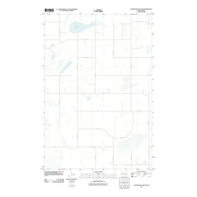
2011 Map of Coldwater Lake NW
USGS Topo · Published 2011About this map
Miller Lake and a high concentration of prairie potholes define this landscape in the southern reaches of North Dakota. The terrain is characterized by a dense network of seasonal wetlands and small water bodies that punctuate the plains, reflecting the glacial topography of the Missouri Coteau region. This 2011 survey documents the rural infrastructure of Roloff Township, where a precise grid of section-line roads, such as 55th Ave SE and 81st St SE, provides access to the agricultural interior. The primary corridor for regional movement is County Hwy 9, which cuts through the southern portion of the quadrangle. For those studying the evolution of Great Plains land use, the map offers a clear view of how modern transportation corridors and section-line tracks like 87th St SE navigate around the natural drainage patterns and numerous small basins that cover the area.
Find a feature on this map
17 named features on this map. Tap any name to fly to it.
Don’t see what you’re looking for? This feature index may not catch every label — zoom into the map to look around manually.
Map Details
Editions of this 2011 Coldwater Lake NW Map
This is the sole edition of this map. No revisions or reprints were ever made.
Other maps of this area

1953 · Jamestown
USGS Topo · 1:250,000

1956 · Jamestown
USGS Topo · 1:250,000

1982 · Coldwater Lake NW
USGS Topo · 1:24,000

1982 · Guyson
USGS Topo · 1:24,000

1982 · Coldwater Lake NE
USGS Topo · 1:24,000

1982 · Fredonia
USGS Topo · 1:24,000

1982 · Ashley East
USGS Topo · 1:24,000
1982 · Coldwater Lake SW
USGS Topo · 1:24,000

1982 · Ashley NE
USGS Topo · 1:24,000
1982 · Coldwater Lake
USGS Topo · 1:24,000