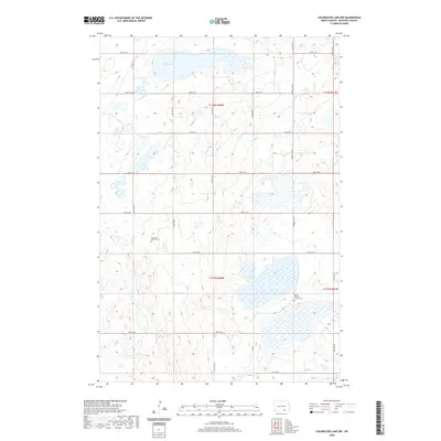
2020 Map of Coldwater Lake NW
USGS Topo · Published 2020About this map
The prairie landscape of t132n r68w and surrounding townships in North Dakota is defined by its glacial potholes and small water bodies, most notably Miller Lake in the north. This 2020 survey reveals a sparse, strictly organized rural grid of section lines and gravel roads that has changed little in its basic structure since the early days of settlement. For those researching the local heritage of McIntosh County, the map provides precise locations for two religious landmarks: the German Baptist Cem and the Berlin Baptist Church Cem. These sites serve as physical markers of the German-Russian immigrant communities that established roots in the region. The transport network remains focused on utilitarian routes like Co Rd 9 and the Federal Aid Rd, which facilitate the movement of goods across this agricultural terrain.
Find a feature on this map
23 named features on this map. Tap any name to fly to it.
Don’t see what you’re looking for? This feature index may not catch every label — zoom into the map to look around manually.
Map Details
Editions of this 2020 Coldwater Lake NW Map
This is the sole edition of this map. No revisions or reprints were ever made.
Other maps of this area

1953 · Jamestown
USGS Topo · 1:250,000

1956 · Jamestown
USGS Topo · 1:250,000

1982 · Coldwater Lake NW
USGS Topo · 1:24,000

1982 · Guyson
USGS Topo · 1:24,000

1982 · Coldwater Lake NE
USGS Topo · 1:24,000

1982 · Fredonia
USGS Topo · 1:24,000

1982 · Ashley East
USGS Topo · 1:24,000
1982 · Coldwater Lake SW
USGS Topo · 1:24,000

1982 · Ashley NE
USGS Topo · 1:24,000
1982 · Coldwater Lake
USGS Topo · 1:24,000