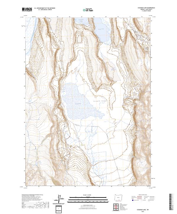
2024 Map of Coleman Lake
USGS Topo · Published 2024About this map
Coleman Valley and the vast basin of Coleman Lake characterize this high-desert portion of Lake County. This modern digital survey shows the critical importance of water management in an arid landscape, where names like Greaser Reservoir and Cahill Reservoir suggest early 20th-century ranching infrastructure. Numerous family-named or descriptively-named water sources, such as Foskett Spring, Burro Spring, and Jackass Spring, dot the terrain, marking essential waypoints across the sagebrush-heavy valley. The mapping of Twentymile Slough and Greaser Lake in the north reveals the seasonal or intermittent nature of hydrology in the Warner Valley region. Connectivity is maintained primarily by Co HWY 3-15, which skirts the western edge of the lake bed, while the surrounding canyons like Greaser Canyon and Jones Canyon rise sharply from the basin floor.
Find a feature on this map
23 named features on this map. Tap any name to fly to it.
Don’t see what you’re looking for? This feature index may not catch every label — zoom into the map to look around manually.
Map Details
Editions of this 2024 Coleman Lake Map
This is the sole edition of this map. No revisions or reprints were ever made.
Other maps of this area

1889 · Long Valley
USGS Topo · 1:250,000

1954 · Vya
USGS Topo · 1:250,000

1955 · Adel
USGS Topo · 1:250,000

1957 · Adel
USGS Topo · 1:250,000

1958 · Vya
USGS Topo · 1:250,000

1958 · Adel
USGS Topo · 1:250,000

1962 · Vya
USGS Topo · 1:250,000

1962 · Adel
USGS Topo · 1:250,000
1966 · Barrel Springs
USGS Topo · 1:24,000
1966 · Little Coleman Canyon
USGS Topo · 1:24,000