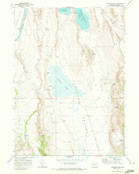
1968 Map of Coleman Lake
USGS Topo · Published 1972About this map
Coleman Valley and the Warner Valley converge in this high-desert basin of Lake County, where seasonal water and alkaline flats dictate the landscape. The 1968 survey reveals a terrain defined by its water management and natural springs, notably Coleman Lake and the Greaser Reservoir. A network of isolated resources supports ranching and survival in this arid environment, including named features like Kuhaya Waterhole, Foskett Spring, and Twentymile Slough. Evidence of human utility appears in the form of a remote Landing Strip, scattered Gravel Pits, and a lone Prospect mark. The map's detail preserves the placement of numerous family-named and utilitarian springs, such as Terry Spring, Jenny Spring, and Jackass Spring, which represent the vital lifelines for the region's early residents and travelers.
Find a feature on this map
28 named features on this map. Tap any name to fly to it.
Don’t see what you’re looking for? This feature index may not catch every label — zoom into the map to look around manually.
Map Details
Editions of this 1968 Coleman Lake Map
This is the sole edition of this map. No revisions or reprints were ever made.
Other maps of this area

1889 · Long Valley
USGS Topo · 1:250,000

1954 · Vya
USGS Topo · 1:250,000

1955 · Adel
USGS Topo · 1:250,000

1957 · Adel
USGS Topo · 1:250,000

1958 · Vya
USGS Topo · 1:250,000

1958 · Adel
USGS Topo · 1:250,000

1962 · Vya
USGS Topo · 1:250,000

1962 · Adel
USGS Topo · 1:250,000
1966 · Barrel Springs
USGS Topo · 1:24,000
1966 · Little Coleman Canyon
USGS Topo · 1:24,000