
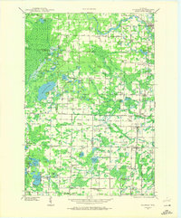
1941 Map of Coleman
USGS Topo · Published 1965About this map
The Peshtigo River winds through the northern reaches of this landscape, punctuated by the Sandstone Dam and framed by a dense network of small lakes and rural homesteads. This 1940s-era field study reveals a deeply localized infrastructure of education and faith, where one-room schoolhouses like White Potato Lake Sch and Flower Nook Sch served dispersed farming families. The boundary between Marinette and Oconto counties is marked by a transition from the forested heights of Kirby Hill and the Beaver Fire Tower to the organized agricultural blocks surrounding Coleman and Pound. Cultural hubs appear in specific enclaves such as the Second Polish Ch and the St Wenceslaus Cem, while the industrial connectivity of the era is anchored by the Chicago and North Western and Chicago Milwaukee St Paul and Pacific railroads.
Find a feature on this map
105 named features on this map. Tap any name to fly to it.
Don’t see what you’re looking for? This feature index may not catch every label — zoom into the map to look around manually.
Map Details
Editions of this 1941 Coleman Map
2 editions found
Other maps of this area

1939 · Porterfield
USGS Topo · 1:48,000

1940 · Thunder Mtn.
USGS Topo · 1:48,000

1940 · Athelstane
USGS Topo · 1:48,000

1942 · Athelstane
USGS Topo · 1:48,000

1942 · Coleman
USGS Topo · 1:48,000

1942 · Breed
USGS Topo · 1:48,000

1942 · Porterfield
USGS Topo · 1:48,000

1942 · Wausaukee
USGS Topo · 1:48,000

1947 · Wausaukee
USGS Topo · 1:48,000

1950 · Coleman
USGS Topo · 1:48,000