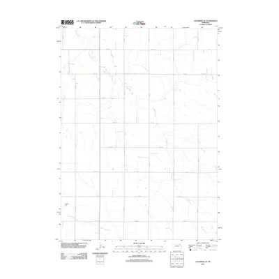
2011 Map of Coleridge SE
USGS Topo · Published 2011About this map
East Bow Creek meanders through this portion of Dixon County, defining the drainage patterns of a landscape deeply organized by the Public Land Survey System. The map reveals a strictly regulated grid of section lines and gravel roads, including 573 Ave and 881 Rd, which provide access to the dispersed farmsteads of Clark Township. In the southwest corner, the Hansen Dam stands as a notable water management feature along the headwaters near North Logan Creek. This 2011 survey captures the area's agricultural character, where the natural wandering of the creek beds contrasts sharply with the straight-edge precision of the rural road network and township boundaries.
Find a feature on this map
18 named features on this map. Tap any name to fly to it.
Don’t see what you’re looking for? This feature index may not catch every label — zoom into the map to look around manually.
Map Details
Editions of this 2011 Coleridge SE Map
This is the sole edition of this map. No revisions or reprints were ever made.
Other maps of this area

1898 · Elk Point
USGS Topo · 1:125,000

1901 · Elk Point
USGS Topo · 1:125,000

1907 · Elk Point
USGS Topo · 1:125,000

1955 · Sioux City
USGS Topo · 1:250,000

1958 · Sioux City
USGS Topo · 1:250,000

1959 · Sioux City
USGS Topo · 1:250,000

1964 · Martinsburg SW
USGS Topo · 1:24,000

1964 · Maskell
USGS Topo · 1:24,000
1967 · Concord
USGS Topo · 1:24,000

1968 · Obert
USGS Topo · 1:24,000