
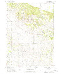
1968 Map of Obert
USGS Topo · Published 1970About this map
The village of Obert sits at the center of this 1960s survey, marking a key settlement point on the border between Cedar and Dixon counties. This area is characterized by its agricultural drainage systems, where Ames Creek and Lime Creek carve through the northern landscape while East Bow Creek flows to the south. The mapping detail highlights a rural social infrastructure that was still clearly visible in the late 1960s, including the Brookey Bottom Sch and Sunny Lea Sch, alongside several rural burial grounds like the Obert Cem and Lime Creek Cem. A Historical Monument is noted in the northern hills, suggesting early pioneer or surveying significance. The presence of several Sandpits indicates local extraction efforts that supported the region's road and construction needs during this period of the Missouri River Basin's development.
Find a feature on this map
17 named features on this map. Tap any name to fly to it.
Don’t see what you’re looking for? This feature index may not catch every label — zoom into the map to look around manually.
Map Details
Editions of this 1968 Obert Map
2 editions found
Other maps of this area

1898 · Elk Point
USGS Topo · 1:125,000

1901 · Elk Point
USGS Topo · 1:125,000

1907 · Elk Point
USGS Topo · 1:125,000

1955 · Sioux City
USGS Topo · 1:250,000

1958 · Sioux City
USGS Topo · 1:250,000

1959 · Sioux City
USGS Topo · 1:250,000

1964 · Martinsburg SW
USGS Topo · 1:24,000

1964 · Maskell
USGS Topo · 1:24,000

1968 · St. Helena
USGS Topo · 1:24,000

1968 · Coleridge
USGS Topo · 1:24,000