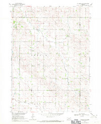
1968 Map of Coleridge SE
USGS Topo · Published 1971About this map
East Bow Creek and North Logan Creek define the drainage of this rural landscape in the Missouri River Basin during the late 1960s. The region is marked by a network of precinct boundaries such as Prec 14 and Prec 15, which underscore the organized civic structure of the time. Local life centers around a series of country schools that served the dispersed farming community, including Branch Sch, Mayflower Sch, and Logan Valley Sch. The presence of St Peter Sch further highlights the integration of education and community life in this agricultural corridor. While the landscape is primarily rural, industrial activity is evident through several resource extraction sites like the Gravel Pits and various Sandpit locations, indicating the local importance of aggregate materials for regional infrastructure.
Find a feature on this map
16 named features on this map. Tap any name to fly to it.
Don’t see what you’re looking for? This feature index may not catch every label — zoom into the map to look around manually.
Map Details
Editions of this 1968 Coleridge SE Map
This is the sole edition of this map. No revisions or reprints were ever made.
Other maps of this area

1898 · Elk Point
USGS Topo · 1:125,000

1901 · Elk Point
USGS Topo · 1:125,000

1907 · Elk Point
USGS Topo · 1:125,000

1955 · Sioux City
USGS Topo · 1:250,000

1958 · Sioux City
USGS Topo · 1:250,000

1959 · Sioux City
USGS Topo · 1:250,000

1964 · Martinsburg SW
USGS Topo · 1:24,000

1964 · Maskell
USGS Topo · 1:24,000
1967 · Concord
USGS Topo · 1:24,000

1968 · Obert
USGS Topo · 1:24,000