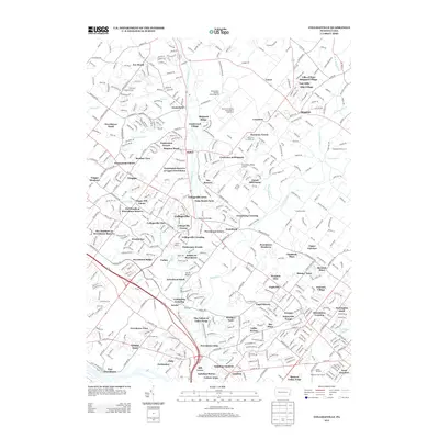
2013 Map of Collegeville
USGS Topo · Published 2013About this map
Perkiomen Cr and Skippack Cr define the landscape of central Montgomery County, where suburban development meets long-standing rural institutions. The massive complex of the State Correctional Institution at Graterford occupies a significant portion of the northern terrain, while the historic Perkiomen Bridge carries traffic into the growing center of Collegeville. The map captures a transition in land use, showing residential clusters like Trappe Meadows and Creekwood Village alongside aviation landmarks such as the Perkiomen Valley Airport and Kunda Airport. This era reflects a densely populated corridor where major transit routes like the Germantown Pike and the Pennsylvania Turnpike Interchange 20 connect diverse settlements from Skippack to Rahns, documenting the region's 21st-century residential character.
Find a feature on this map
93 named features on this map. Tap any name to fly to it.
Don’t see what you’re looking for? This feature index may not catch every label — zoom into the map to look around manually.
Map Details
Editions of this 2013 Collegeville Map
This is the sole edition of this map. No revisions or reprints were ever made.
Other maps of this area

1888 · Quakertown
USGS Topo · 1:62,500

1890 · Quakertown
USGS Topo · 1:62,500

1894 · Quakertown
USGS Topo · 1:62,500

1894 · Norristown
USGS Topo · 1:62,500

1895 · Norristown
USGS Topo · 1:62,500

1896 · Norristown
USGS Topo · 1:62,500

1902 · Boyertown
USGS Topo · 1:62,500

1906 · Phoenixville
USGS Topo · 1:62,500

1942 · Norristown
USGS Topo · 1:125,000
1943 · Telford
USGS Topo · 1:31,680
Featured Places
- Limerick Township, PA
- Phoenixville, PA
- Skippack Township, PA
- Worcester Township, PA
- Perkiomen Township, PA