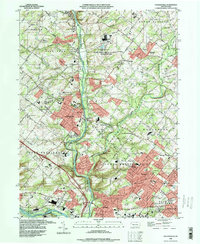
1992 Map of Collegeville
USGS Topo · Published 1998About this map
Ursinus College stands as a central landmark in this suburban landscape, situated near the intersection of Ridge Pike and the Reading railroad line. The map illustrates a dense network of early crossroads and institutional land use, dominated in the north by the State Correctional Institute at Graterford and its surrounding Central Perkiomen Park lands. The southeastern corner shows the early development of Audubon and Jeffersonville, where the Mill Grove / Audubon Wildlife Sanctuary preserves the area's natural history along the winding Perkiomen Creek. The presence of the Schuylkill Canal near Mont Clare and Port Providence reflects the long-standing industrial reliance on the Schuylkill River. Researchers will find a mix of educational and religious heritage preserved in labels for the Collegeville-Trappe High Sch, Keelys Ch, and the Methacton High Sch.
Find a feature on this map
77 named features on this map. Tap any name to fly to it.
Don’t see what you’re looking for? This feature index may not catch every label — zoom into the map to look around manually.
Map Details
Editions of this 1992 Collegeville Map
This is the sole edition of this map. No revisions or reprints were ever made.
Other maps of this area

1888 · Quakertown
USGS Topo · 1:62,500

1890 · Quakertown
USGS Topo · 1:62,500

1894 · Quakertown
USGS Topo · 1:62,500

1894 · Norristown
USGS Topo · 1:62,500

1895 · Norristown
USGS Topo · 1:62,500

1896 · Norristown
USGS Topo · 1:62,500

1902 · Boyertown
USGS Topo · 1:62,500

1906 · Phoenixville
USGS Topo · 1:62,500

1942 · Norristown
USGS Topo · 1:125,000
1943 · Telford
USGS Topo · 1:31,680
Featured Places
- Limerick Township, PA
- Phoenixville, PA
- Skippack Township, PA
- Worcester Township, PA
- Perkiomen Township, PA