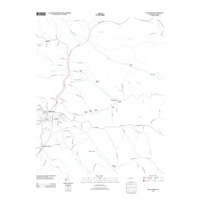
2013 Map of Collinwood
USGS Topo · Published 2013About this map
Collinwood serves as the primary hub in this southern Tennessee landscape, where the town’s grid is flanked by the smaller communities of Woodlawn and McGlamery Stand. The modern transit corridor of the Natchez Trace Pkwy snakes through the terrain from north to south, intersecting the town and crossing high ground like Shelton Ridge. This area is defined by a dense network of drainages including the Green River, Shawnette Cr, and the triple forks of First Butler Cr, Middle Butler Cr, and Last Butler Cr.
Find a feature on this map
117 named features on this map. Tap any name to fly to it.
Don’t see what you’re looking for? This feature index may not catch every label — zoom into the map to look around manually.
Map Details
Editions of this 2013 Collinwood Map
This is the sole edition of this map. No revisions or reprints were ever made.
Other maps of this area

1905 · Waynesboro
USGS Topo · 1:125,000

1936 · Westpoint
USGS Topo · 1:24,000

1936 · Collinwood
USGS Topo · 1:24,000

1936 · Light
USGS Topo · 1:24,000

1936 · Negro Hollow
USGS Topo · 1:24,000

1936 · Cypress Inn
USGS Topo · 1:24,000

1936 · Three Churches
USGS Topo · 1:24,000
1936 · St. Joseph
USGS Topo · 1:24,000

1936 · Waynesboro
USGS Topo · 1:24,000

1936 · Ovilla
USGS Topo · 1:24,000