
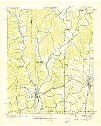
1936 Map of Westpoint
USGS Topo · Published 1936About this map
Westpoint serves as a focal point in this 1936 study of the Tennessee and Lawrence County borderlands, situated where Chisholm Creek and Factory Branch converge. The landscape is defined by a dense network of rural infrastructure, including a prominent Tennessee Electric Power Company Transmission Line that bisects the terrain. Smaller settlements like Pinkney, Lodi, and Chinubee are interspersed with numerous local institutions that were central to rural life in the mid-1930s. Education and faith are well-represented by facilities such as Silver Springs Sch, McCrory Sch, and Bethlehem Ch. The terrain features distinct ridges like Sims Ridge, while the waterways, including Shannatee Creek and Double Branch, suggest a well-watered agricultural and timber environment prior to later 20th-century developments.
Find a feature on this map
55 named features on this map. Tap any name to fly to it.
Don’t see what you’re looking for? This feature index may not catch every label — zoom into the map to look around manually.
Map Details
Editions of this 1936 Westpoint Map
This is the sole edition of this map. No revisions or reprints were ever made.
Other maps of this area

1905 · Waynesboro
USGS Topo · 1:125,000

1936 · Deerfield
USGS Topo · 1:24,000

1936 · Collinwood
USGS Topo · 1:24,000

1936 · Light
USGS Topo · 1:24,000

1936 · Negro Hollow
USGS Topo · 1:24,000

1936 · Long Branch
USGS Topo · 1:24,000

1936 · Loretto
USGS Topo · 1:24,000
1936 · St. Joseph
USGS Topo · 1:24,000

1936 · Ovilla
USGS Topo · 1:24,000
1950 · Westpoint
USGS Topo · 1:24,000