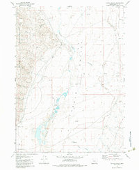
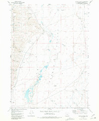
1981 Map of Colony Ranch
USGS Topo · Published 1981About this map
Pueblo Mountains dominate the western edge of this High Desert landscape, where the terrain drops sharply into the Pueblo Valley (Depression). The map details a specialized ranching and water-retrieval network centered on Colony Ranch and the unusual designation of Poor Farm. Surface water is scarce, concentrated in the Pueblo Slough and various ephemeral drainages like Pueblo Creek and Cottonwood Creek.
Find a feature on this map
32 named features on this map. Tap any name to fly to it.
Don’t see what you’re looking for? This feature index may not catch every label — zoom into the map to look around manually.
Map Details
Editions of this 1981 Colony Ranch Map
2 editions found
Other maps of this area

1886 · Disaster
USGS Topo · 1:250,000

1893 · Disaster
USGS Topo · 1:250,000

1954 · Vya
USGS Topo · 1:250,000

1955 · Adel
USGS Topo · 1:250,000

1957 · Adel
USGS Topo · 1:250,000

1958 · Vya
USGS Topo · 1:250,000

1958 · Adel
USGS Topo · 1:250,000
1961 · Trident Peak
USGS Topo · 1:62,500

1962 · Vya
USGS Topo · 1:250,000

1962 · Adel
USGS Topo · 1:250,000