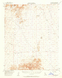
1956 Map of Colton Well
USGS Topo · Published 1962About this map
The 7 IL Ranch stands as a focal point of settlement in the north-central San Bernardino desert, situated near the head of Barber Canyon. In the mid-1950s, this landscape was defined by the precarious search for water and minerals, evidenced by a network of isolated outposts like Colton Well, Bearclaw Well, and Bonanza King Well. Resource extraction is prominent throughout the terrain, with the Silver King Mine in the northwest and the Goldhammer Mine further south, connected by a series of primitive routes including the Hidden Valley Road and various jeep trails. To the south, the Clipper Mountains rise sharply above Hidden Valley, offering essential water sources like Chuckwalla Spring and Hummingbird Spring. The mapping of the Blind Hills and Halfway Hill illustrates the importance of high-ground triangulation points like Colton VABM 3405 for navigation in this arid environment.
Find a feature on this map
41 named features on this map. Tap any name to fly to it.
Don’t see what you’re looking for? This feature index may not catch every label — zoom into the map to look around manually.
Map Details
Editions of this 1956 Colton Well Map
2 editions found

Other maps of this area

1910 · Ivanpah
USGS Topo · 1:250,000

1912 · Ivanpah
USGS Topo · 1:250,000

1942 · Ivanpah
USGS Topo · 1:250,000

1942 · Amboy
USGS Topo · 1:250,000

1943 · Amboy
USGS Topo · 1:250,000

1943 · Essex
USGS Topo · 1:62,500

1943 · Danby
USGS Topo · 1:62,500

1943 · Fenner
USGS Topo · 1:62,500

1947 · Kingman
USGS Topo · 1:250,000

1948 · Kingman
USGS Topo · 1:250,000