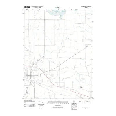
2010 Map of Columbia City
USGS Topo · Published 2010About this map
Columbia City serves as the central hub of this Whitley County landscape, where the confluence of several vital watercourses dictates the local geography. The Blue River and the Eel River wind through the region, supported by an extensive network of drainage systems including the Miller Ditch and Mowrey Ditch, illustrating the managed water levels necessary for the area's agricultural and residential development. To the north, the cluster of recreation-oriented water bodies known as Tri-Lakes—comprising Shriner Lake, Cedar Lake, and Little Cedar Lake—stands in contrast to the more linear settlement patterns found at Coesse and Cresco. This 2010 survey also highlights several significant community sites for genealogists, including South Park Cemetery near the city center and the more outlying Garrison Cemetery and Nolt Cemetery, which provide ties to the area's historical family lineages and rural development.
Find a feature on this map
75 named features on this map. Tap any name to fly to it.
Don’t see what you’re looking for? This feature index may not catch every label — zoom into the map to look around manually.
Map Details
Editions of this 2010 Columbia City Map
This is the sole edition of this map. No revisions or reprints were ever made.
Other maps of this area

1951 · Ormas
USGS Topo · 1:24,000

1951 · Merriam
USGS Topo · 1:24,000

1953 · Fort Wayne
USGS Topo · 1:250,000

1955 · Columbia City
USGS Topo · 1:24,000

1955 · Ege
USGS Topo · 1:24,000

1956 · Fort Wayne
USGS Topo · 1:250,000

1956 · Lorane
USGS Topo · 1:24,000

1957 · Churubusco
USGS Topo · 1:24,000

1961 · Arcola
USGS Topo · 1:24,000
1961 · Laud
USGS Topo · 1:24,000